Tuesday, March 31, 2020

Hiking attempt from the East Baboquivari Trail Head. Didn't get far.

I woke after sunrise again, it felt great but I may have missed a good sunrise based on the cloud formations I saw when I raised the curtains.  Oh well.


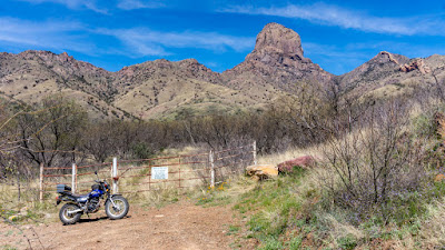
After breakfast and once it had warmed up a bit, I geared up and again rode Yagi, my '06 Yamaha TW200 to the trail head for the eastern trail to Baboquivari Peak.  I intended to just hike to the saddle described in Todd's posting but didn't even make it that far!

source: see Todd's Posting link

One thing missing from Todd's posting about hiking the eastern trail to the top of Baboquivari Peak:  The plethora of thorny bushes along the narrow trail!  Shorts, were not the way to go for this hike.

I'd worn shorts as the day promised to be quite warm.  Ironically, I should have kept on my Kevlar Mesh Riding Pants as anything else I think would have failed to protect my legs from scratches and thorns.
 Gnarled tree guards the path soon after leaving the buildings
comprising the small "ranch" behind.
 Part of the hiking trail, the puddle provided for
an artsy shot.

 These is one of two large water tanks that show up on the map,
about a third of the way from the trail head gate area.

The area after the water tanks is where the trail got faint and confusing.  I tried several times, but each time ended up struggling through lots of thorny bushes to find my way back to the water tanks.

The rock formations above the water tanks seemed to make a face at me as it watched me struggle to get out of thorn bushes and steep rock strewn "trails".


After several attempts to stay on trail, I gave up, the alluded rock cairns proved as difficult as the trail to find, in my case anyways.

Below is my closest view of Baboquivari Peak for today:


I retraced the trail, continuing to try and avoid the thorny branches of bushes alongside the trail, and finally made it back to the ranch buildings:


From the ranch site, one can get a good look at the rock ridge that lies like a snake along the top of the ridge pointing towards the peak:


Caretaker's Lodgings?  Apparently not occupied fulltime

A better look at the wall-like rock formation leading away towards
the top of Baboquivari Peak

Got back to Yagi and got geared up to go riding again.  The riding pants and jacket would have protected me from the thorny bushes but I would have probably suffered heat exhaustion.  Oh well.

Rode back and noticed the crazy driver of the Class C Motor Home I'd spotted yesterday was gone now.  I rode on, still marveling that he'd managed to get his motor home over some of the really sketchy and rock strewn portions that I had to slow down to traverse on Yagi!

I actually caught up to him about a couple of miles from my campsite, I exchanged "OK" signs with him and I kept going while he continued onwards much more slowly.

Got back to camp, oiled Yagi's chain, applied antiseptic ointment to all the scratches on my hands and legs and soon I spotted his motor home in the distant ridge:

Can you spot his RV?

As I waited for him to get closer to camp, I took another picture of Fiona with the unnamed rock formation closest in the background and Mount Wrightson in the far distance.


Eventually, the guy and his RV showed up closer and I took pictures of his rig as he went on by.  We waved at each other but he just kept on driving, heading for the highway about 2.5 miles away.  I am sure he felt the remaining miles were smooth as silk when compared to the crap he'd just driven his motor home on!  Crazy guy.


Another shot of Fiona with Mt Wrightson in the background.  The closer rock formations are unnamed as far as I can determine.


Cloudy, overcast skies precluded any view of the setting sun.  Alas.


Monday, March 30, 2020

T-Dubing to the Baboquivari Peak East Trail Head

An easy day of riding my '06 Yamaha TW200, Yagi.

Didn't get out of bed till almost 7AM, it was quite luxurious but there was one call of nature around 4:15 AM so its not like I slept through the whole night.

Woke to 38°F (3.3°C) and didn't have to turn on the catalytic heater to take the chill out of the air as the morning sun was doing a good job of warming things up inside the URRV.


Lounged about, taking the above pictures and planning picture shot angles for later on around the campsite.

Before 10:00 AM, I geared up and rode out on Yagi taking the trail that leads from the campsite through to Thomas Canyon, trying to see how far I could get before I ran out of trail as shown in the map:


The trail proved pretty easy with only a couple of parts where I slowed down a bit but could have taken at speed.  By speed of course is a rate that never exceeded 20 mph!  Captain Slow, that's me!  Still, it wasn't exactly conditions where one would take a 2WD car on, at least that's what I thought.


As I got closer to the gate, I crested a small hill and damned if I didn't see a small Class C similar in size to Uma sitting on a hilltop.  What the hell I thought, how did he get that sucker here on this trail!?!?

I was too surprised to take pictures inbound, so here's a couple I took on the way back to show the view I had when I topped the hill:

 You see it, left of center....


I closed the distance and stopped at the trail junction to talk to the driver.  I confirmed with him that he'd actually driven the motorhome down the sometimes nasty trail!  He patted the side of the motorhome and said yeah, but never again!  He's going to have such a good time getting that thing out safely!

Note, he was parked by the junction where a sign said no camping further on.  I guess that's why he stopped?

Talking across the 50 ft or so distance, got tiring fast, so I waved goodbye and kept going till I hit a small stream.  A brief recce confirmed the stream wasn't the end of the trail; so after returning to Yagi and kept on going for perhaps another half mile until I did hit the gate.


I hadn't packed any hiking gear so it'll have to wait, the link for the map talks more of the hike.  I would just be doing the portion that is accessible on foot without the three technical climbs that are involved to get to the top of Baboquivari Peak!

Here's a pic of the stream on the way back:


Here's a couple of pics of the motor home as I made my way back up from the stream bed:

 See it?  Look at the bottom of the V


Still shaking my head and deciding the guy was nuts to bring a motor home down the trail he did, I made my way back with no issues.

Blue distant peaks

Back at the campsite, I took a quick spin to check out the trail going to Mildred Peak.  Nice and straight for the most part with speeds reaching almost 30 mph it was in such a good condition.

Unfortunately, the trail deadends at someone's home and the designated route from there to Schaffer's Wash and Camp is foot traffic only.  Oh well, this is as close as I would get to Mildred Peak:

Mildred Peak

As I neared the campsite, I stopped for this wide view of it and the area to the north:

Can you spot Uma?

A late lunch and just relaxed the rest of the afternoon away, it would get as warm as 73°F (22.7°C) and it felt nice though there was a breeze in the shade that was almost uncomfortable.  It's supposed to be warmer tomorrow, I might go on that hike.

Sunday, March 29, 2020

Moved to new campsite near Schaffer Wash, AZ

Sunday, March 29

Finally the cold front is past my location, it would get into the low 70's though a bit windy at times.  Warmer the next few days.

Today’s sunrise was meh:


Note, it only got down to about 38
°F (3°C) overnight, so not bad.  Still cranked up the heater once I got up though.  Here's a couple of pics of Baboquivari Peak from the door of the URRV from campsite 41 within the Buenos Aires NWR.


After breakfast and once it had reached almost 50°F (10°C) I geared up with extra layers and rode out on Fiona, my ‘99 Ural Patrol.  I've basically lost my ability to withstand any kind of cold weather now.

The objective was to get closer to Baboquivari Peak and use it as a background for Fiona pictures.

I turned down this private road which is open to the public for use by sportsmen and hunters.   I hadn’t used this road before and it looked promising as to getting me closer to the peak.  


I ended up at this campsite next to trail junction leading to Mormon Corral.  I was curious about the name so I wandered down the road to see it.  It turned out to be pretty anti-climatic:


Heading back to the trail junction I posed Fiona for in front of a much closer Baboquivari Peak:


 Fiona sitting in the middle of an established campsite

To the east of the campsite, across AZ Highway 286, is Mount Wrightson:


I checked out the campsite some more after ascertaining the rules for camping.  The major one is you cannot be within 1/4 mile of a water source or storage tank.


Sign at the entrance

Decided to move the URRV to this spot after some thought.  Rode back to site 41 in the Buenos Aires NWR by 1130 am and packed things up hastily, within 30 minutes I was ready to move!

By 1215 pm I was at the new site and set up camp (mostly) by 1 pm.  There was a virtual tour of Bob’s BMW personal garage you see, and I was curious as to the content and the technology for such meetings in the new “now”.  

The app to be used was Zoom.  Not bad.  Zoom is apparently being used by some educators to provide online classes during the virus debacle and associated lock downs.  There is of course a learning curve and the tour was interrupted at times by people clearing their throats or making some other noise and the screen shifting to them.  Oh well.

Here's some screen captures I made while watching the tour on my iphone:


 I think this is the last R100R made


Bob has some nice toys, he owns the largest BMW specific dealership in the Mid-Atlantic region apparently.

I found the tour interesting though there was more talking and less showing that I’d hoped for; still it was free eh?  I had thought it was going to be a tour of the museum itself that Bob owns but no, just the contents of his garage.

After the virtual tour, it was time for some pictures of the new campsite.  I really like it a lot and hope it becomes a regular site for me


Mo Better eh?

The afternoon warmed up nicely with occasional gusty winds from the NW but not too bad.


I like this location.

Here's pics from today's sunset:


Saturday, March 28, 2020

Back in Buenos Aires

The Buenos Aires National Wildlife Refuge that is!

I've boondocked here before and this time the spot with the best view of Baboquivari Peak was open for my use.

Turns out, only one other camper in the immediate area, and he turned out to be one of the folks who've commented on my pictures on Facebook!  Small world.

I arrived around noon on Friday, March 27, but strong winds and a cool front kept me "sheltering in place" inside the URRV after I set up camp.

Saturday, March 28:

It would prove to be much warmer this afternoon than yesterday afternoon.  I did wake to slightly below freezing temperatures in the URRV though.  I'd enough blankets overnight to keep me warm but getting up in the morning proved "brisk" until I got the catalytic heater going!


Yagi and Baboquivari Peak

Once it had warmed up to about 50°F (10°C), I geared up with a couple of warming layers under the riding jacket and rode the 13 miles or so to the nearby town of Arivaca to get some AAA batteries for my inside thermometer.  I picked up some sundry supplies as well.

Before the grocery chore though, I rode east of town about three miles to pose Fiona, my '99 Ural Patrol with Keystone Peak and Cerro Colorado in the background:

Keystone Peak is right above Fiona, the rest is
the Cerro Colorado according to Peak Finder app.

Lunch and the first half of the afternoon was spent hanging about the URRV, doing some light chores.

Around 3PM, I rode out on Yagi, my 2006 Yamaha TW200 to explore some of the trails in the NWR that I'd not ridden before.

One of the trails led me to atop a small hill with this view of Baboquivari Peak:


I explored some more trails, always turning back when things got a bit too steep or rocky or both!

Then I went to ride the 297 Trail which is a loop that ends up at campsite #36 where I had boondocked before.  I found myself at what I will call a Rescue Beacon Tower.  It has a spinning set of cups on top which reflect the sun to catch the eye, and at night a police blue LED blinks to advertise it's location.

I'd seen this blue light blinking in the dark before when camped at site #36, but hadn't found it before today.


After taking the above pictures, I rode down a side trail marked as 296.  It ended for me at a steep downhill rock strewn goat trail so I turned around back to the beacon.

There I found a Border Patrol agent, apparently looking for me!  Although I'd not pushed the red button to call for help, the camera I saw above the box with the emergency phone had apparently captured my image and alerted the nearby agent.

He and I chatted, he had just come by to make sure all was well with me, which I appreciated.  I was a bit surprised the camera was monitored real time but perhaps it just generated an alert for the Border Patrol as part of the safety protocol/patrols they run.

Back at camp, I worked on sewing up some damage on my riding boots.  I'd been "making do" with Gorilla Tape for quite a while now, but now they're properly sewn up.  As I finished the repairs, it was time for sunset pictures: