Showing posts with label Weather. Show all posts

Sunday, June 09, 2024

Hail and a Day Ride on Rampart Range Road

 Sunday, June 9

We got a severe thunderstorm warning and shortly afterwards got hit by heavy rain and marble-sized hail (some almost golf ball-sized)!


Buildup from the gutter drain pipe out front

During the peak of the hail storm:


Thing 2's Toyota Pickup Truck got lots of hail damage on its horizontal surfaces.  I'm presently waiting to see how a neighbor's damage survey goes with USAA, an insurance company we both use, to see if I should ask for an inspection as well.

The roof tiles are less than six months old so hoping they withstood the hail's impacts.

Update: July 3.  Roof Inspector checked out our roof and declared it good.  Some minor damage and definitely some dents on the roof vents but nothing to cause me to file an insurance claim!

Wednesday, Jun 12

No chores, so went for a day ride on Scarlett to check out road conditions and campsite availability on Rampart Range Road in the Pike National Forest.  It's about a 2 hour ride each way which highlighted to me how out of shape I've gotten in terms of long hours in the saddle!

Lots of campsites in the Fee Area and also in the dispersed camping area closer to Woodland Park.  Road conditions were dry, a lot of washboard and some gravel in spots.  I did find a couple of new sites and recorded them accordingly on Google Maps.

Some views of Pikes Peak and road conditions:

Topaz Point


As you can see, things clouded up pretty good as the afternoon wore on.  I would end up getting sporadically rained on as I rode home via Colorado Springs and CO Hwy 83.

The winds got really strong and gusty as I neared Parker, CO and it felt like I was getting sand blasted when it picked up the road dirt!

Got home just fine, Scarlett did great and she went over 75,000 km during this ride.  So I changed out her engine, transmission and final drive oils before dinner.  The next day, checked Scarlett's valve clearances - AOK.

Also checked Yagi, TW200's valve clearances, found intake too tight for .003/.004, loosened and adjusted to loose for .003 and very snug for .004.  Exhaust was fine.

Tuesday, February 14, 2023

A Sudden Displacing to Yuma, AZ

Monday, February 13

We woke to overcast skies and cold rain after a gloriously sunny but windy day yesterday.

By late morning, and given the high winds advisory published for the next day, we decided to cut our stay in the Barry Goldwater AF Range short.

We left after 1 PM and were in the Yuma area about two hours later.  As we all had chores to take care of in Yuma, we chose a couple of spots in a very crowded BLM area near the VFW location north of Fortuna Hill on the outskirts of Yuma.

It was crowded, noisy with passing trains and planes, but for one night it was fine.

Tuesday, February 14

Left the VFW BLM site just before 8AM to work on errands.  The first one was signing up for storage for Scarlett, my 2014 Ural Patrol and the Aluma 638 trailer I use to haul the sidecar rig around on.

Shortly after 9AM the paperwork was done and I left Scarlett and trailer in storage for the next couple of months or so.


The Z's and I will be stashing more stuff into this space before we head south into Baja California next week.  

Next was the printing of all the paperwork we needed to get a Tourist Visa aka FMM in order to be in Baja California.  We also printed out the insurance policies we got for our respective rigs and TW200 motorcycles.  Lots of money spent, but the chance to do this explorative travel into Baja with the Z's could not be passed up by me.

Final chore for the day was picking up pre-ordered Mexican Pesos from the Wells Fargo Bank.  Nice exchange rate of almost 18 pesos to the dollar!  I hope to be able to use the credit card where possible, but having cash will be handy I think.

I finished slightly ahead of the Z's with chores so I headed out to the Ogilby Road BLM Dispersed Camping site about 20 miles away.  It's located just over the border between Arizona and California, so I made sure to gas up the VRRV before leaving Arizona!

Found a nice spot for our rigs and set up camp while awaiting the arrival of Lori and Chris:


Here's a time lapse of the above scene to show the fast moving cloud conditions we had this afternoon.


The above pics and movie were shot with my Pixel 4a's camera because I managed to drop and damage the 16-50mm stock lens that came with my Sony A6000!  I was switching between it and my telephoto lens you see, clumsy!

The lens didn't crack but the housing split
and there was internal damage.

Luckily, the camera and lenses are covered by my existing insurance policy and they'll be cutting a check for me to cover the cost of my buying a replacement via Amazon.  

The replacement lens will be here Friday this week so my clumsiness will not impact my ability to shoot pictures with the Sony camera while in Baja California.

As I typed this, strong winds and dust storms were buffeting the rigs!  After the peak winds, I went out for some shots of the dust storm conditions.


Friday, April 26, 2019

Nice, then scary, then nice weather day

Not much riding today, work kept me pretty busy along with rigging up a light to show the water level in the fresh water tank; since the monitoring sensor has gone on the fritz this trip.

No sunrise pics for this posting.  Kept looking out the wrong window when deciding whether to get up or not to capture the sunrise.  Doh!

The weather was sunny to partly cloudy all morning and until perhaps 3:30 PM, shortly before then then I watched dark clouds approaching from the west along with some pretty strong wind gusts at times.

 Storm clouds approaching from the West

 Shortly after I took this picture, a wind gust hit Yagi
on the left, and knocked her over.

The view to the East before the storm arrived.

Then, I felt a few rain drops, heard a crash as Yagi toppled over, and all of a sudden it was like Mother Nature flicked a switch and I was in the middle of a wind storm with some rain in the mix!  The winds were coming from the west so hitting the URRV on its left side causing it to rock at times.

I hurriedly brought everything in, starting with the slideout which didn't like the wind hitting it at all!   Everything buttoned up, I was ready to start the URRV and point her into the wind.

Then, Mother Nature flicked that switch again, and it was bright skies, puffy clouds and warm temperatures again.  The saying is for Colorado, if you don't like the weather, wait five minutes, it'll change.  Today I was reminded of this....a pretty awesome display of Mother Nature's forces.  The whole thing was perhaps 20 minutes of "interesting" weather.

 After the brief storm, nice skies again.....

The rainbow was a parting gift from Mother Nature.

Now, sunny and 78°F (25.5°C) as I type this.....it's like the storm never happened.

Tonight's sunset was a non-event....low clouds blocked the horizon and so blocked the light from the setting sun.  Oh well.


Wednesday, November 10, 2010

First snow for the season, still no Natasha....but I did ride.

Yesterday's rain/snow mix resulted in about an inch of snow accumulation on the grassy areas of the neighborhood and not much of anything that I could see from my garage door.  That is, a nice icy cover of frozen snow on my driveway.

Normally, I would have laughed it off and fired up Natasha, my Ural Sidecar rig and ridden off to work at the normal time.

Sadly, she's still in the shop, waiting for some part.  I am told it's inbound (again) and maybe they'll even send the right part.  I am not so confident anymore and refuse to have my hopes dashed once again.

So, I decided to work from home, doing a bit of telecommuting.  But before the day started for me, a little bit of shovel work, along with a special tool for chipping away at ice and finally a bit of snow melt salt, and I had me a path out to the dry cul-de-sac:


As expected, the roads in the neighborhood and the main roads were dry though there was the occassional wet looking spot in the shade that made one wonder.  These I managed to avoid, for the most part, or made sure to just cross while making no turning maneuvers.  It was a short ride as the sun had barely been up an hour and had not done its magic.

As I worked the rest of the morning, dutifully I might add, I could hear the snow melting off the roof and making noises as it fell off the roof edges.

Lunch time came about and I headed out once more to truly dry roads and bright sunshine.  It was a balmy 29°F as I rode to the Beemer dealer to have my battery checked out.  You see, as I went to start the R80 Beemer I call Brigitta yesterday afternoon, she balked.  Mind you, it was hailing lightly and the clouds were fearsomely dark and the wind was waiting to snatch me up into the sky.  No pressure.

Oscar, my co-worker friend came to the rescue with jumper cables, I got Brigitta going and got home only mildly wet and slight chilled.  I thought my battery was just too old.

So there I am at the dealer and they graciously broke out the tester and hooked it up to Brigitta, the battery was pronouced "good".   Hmmmm.  They did suggest that I change out the oil as I was still running the 20W50 oil for the summer.  I had been planning to do this in about 1000 miles but elected to do it this afternoon.

It's good that I did!  I found the rubber donut seal had been slightly damaged by the metal o-ring type disk and hence the slight oil leakage I'd been trying to figure out lately.

The oil has now been changed, the battery is all charged up.  So of course we're expected to wake up to 1-2 inches of snow tomorrow, Thursday, Veteran's Day.  Sigh, I really miss Natasha.

Monday, July 27, 2009

"Riding in the Rain"

Today as I left work close to 4:00 PM, the storm clouds were gathering and a few drops of rain were starting to fall in the parking lot as I got ready to ride Brigitta, my 1987 R80 Beemer home from Denver International Airport.

Flying debris was everywhere as the winds were picking up and blowing from the North/Northwest. I headed out and straight into some strong gusty winds, hitting me on the right side and causing me to lean Brigitta over or be pushed into the adjoining lane. I hate wind from the right side, left side...not so much.

I got to "enjoy" these windy conditions for several miles until at last my chosen route home had me heading in a southerly direction. Now with the wind at my back, all was quiet and relatively still. I chose a route that avoided much more exposure to southbound winds on my right side and the rest of the ride was great.

The rain continued and grew in strength, there was buckets of the stuff! And yet, it did not bother me. I was dry with my waterproof liner under my riding jacket, my pants were getting wet but I was heading home so no matter there. The rain was falling thickly but gently with almost no wind. It was great!

So great in fact in evoked in my minds eye that scene from that old movie where Gene Kelly is dancing about in a rain-soaked street, singing that well known song: "Singing in the Rain".

I was finding the whole riding in the rain experience, after those wicked wind gusts coupled with rain, so peaceful in comparison that I tried singing the following lyrics. Really, I was having such a good time, rain coming down in buckets, that I was weaving in my lane (safely), as I am prone to do when enjoying some nice tune when on the highway.

So I give you here, the paraphrasing of the first verse of the song, sung to the tune of "Singing in the Rain":

Riding in the Rain

I'm riding in the rain
Just riding in the rain
What a glorious feelin'
I'm happy again
I'm laughing at clouds
So dark up above
The sun's in my heart
And I'm doing what I love
Let the stormy clouds chase
Every cager from the place
Come on with the rain
I've a smile on my face
I ride down the lane
With a happy refrain
Just ridin',
Ridin' in the rain


Sunday, June 07, 2009

Georgetown, CO and The Guanella Pass Road

Though the weather forecast called for only 30% chance of precipitation with a high of 70°F today. The skies looked clear enough in the morning for me to try for a "then and now" shot of Georgetown, CO.

Georgetown is located along I-70 a few miles west of Idaho Springs. I made my way to Georgetown using the I-225/25 slabs to get to westbound I-70. Again, I exited at the US40 junction and used this more sedate road to enter the mountains of the Front Range.

Once past Genesee, I elected to stay on I-70 westbound and not take the Floyd Hill turnoff to get back onto US40. Traffic was medium heavy at most and the weather was sunny though temperatures were "brisk".

I arrived at the turnoff for Empire, CO and decided to check out Old Georgetown Road out of Empire. This road starts off as Main Street in Empire. Before I turned onto it though, I stopped to pose Brigitta at the original "Hard Rock Cafe". Apparently the chain of similarly named cafes
owned by movie stars tried to sue them over the use of the name and got laughed out of court. You see, this cafe has been around way before those movie stars were anything but wannabe actors.

The very first Hard Rock Cafe

Picture taken, I turned onto Main Street and headed south out of the town of Empire. This turned out to be a road I had been down before on Maria, my 2004 R1150RT. It was during my passbagging efforts, and I'd ended up before stopped before a rock strewn narrow pass known as Empire Pass where I dropped Maria while trying to turn her around. Here's a link to that sorry day: LINK.

I parked Brigitta on the side of the trail, walked up to the pass and took the following shots:

The view from Empire Pass


I carefully backed Brigitta back down the hill using the engine off, transmission in gear, clutch lever as brake method and successfully got her turned around. I rode off down the rocky trail back towards Empire. From Empire I took the I-70 route to Georgetown, about three miles away. I exited at the second Georgetown exit and followed the signs towards the "Old Town". I saw and followed the signs for the Georgetown Loop Railroad and parked near the historical marker to show you a picture of the trestle bridge which is still in operation.

The Georgetown Loop Circa 1884
go to DPL: Call# CHS.J4060

Georgetown Loop Circa 1884
go to DPL: Call# WHJ-1084

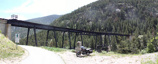
The Georgetown Loop Trestle Bridge

Click to photo to read the plaque

I rode back into town, past the unseeing local yokels who apparently have a habit of just stepping off into the street without looking, and found the road to Guanella Pass by the simple expedient of heading west across the town until I saw the signs.

It's this same dirt/gravel road which takes one above the town of Georgetown and after some searching, I carefully maneuvered Brigitta onto the only really clear spot I could find to take these pictures:

Georgetown Circa 1880
go to DPL: Call #X-1325
Note the lack of trees, all chopped down for building and burning!

Georgetown circa 1930
go to DPL: Call# x-1012

Georgetown, 2009

Turns out, had I just gone on through the next hairpin turn, there was a nice open spot for the same pictures! So if you're going to try the shot above, just go to the first hairpin.

I kept going up towards Guanella Pass. The road is rock strewn, full of potholes, loose gravel, some big dips and runoff-created channels as well. Brigitta did fine though there were moments I briefly hesitated. There was road construction as well which resulted in my waiting along with a line of cagers for our turn to go down two sections of "one lane roads". So, if you don't fancy dirt riding, and trust me I was wishing for a GS on some of the spots, wait till they finish construction in the Fall of 2010. The construction they're doing seemed more like destruction to me but what do I know. I noted that some of the more "lower slung" cars were having more
difficulty than I at negotiating the road conditions.

Really, besides the few moments were I could not avoid muddy looking gravelly areas, it was fine on Brigitta. I even did some standing on the pegs to traverse some of the more "gnarly" areas.

So, once I cleared the construction zone, the road got much better, go figure! Now it was just packed dirt with small loose gravel and some washboarded spots. I made good time all the way to the top of Guanella Pass. It's summit is at 11,669 ft and the road itself is 24 miles long,
with Georgetown at the north end and Grant at the south end.

The view when I first arrived, heavily overcast, I hung around for perhaps 30 minutes hoping for a break in the cloud to let in some sunlight. The sharp edged ridge is Sawtooth Ridge.

While I waited, it snowed, no stick but still....

This was the best of several pano shots I took while I had some sunlight, that's Mt Bierstadt on the right, Sawtooth Ridge in the middle and I think Mt Evans further back.

The requisite photo at the Pass Marker

Weather conditions I faced on the way down

I rode down towards Grant, CO. Road conditions were about the same as the top of the pass. Packed dirt, washboard sections and loose gravel with the occasional exposed boulder one avoided easily. Though I was keeping speeds up to about 25mph on the road, I had to move over and let cagers careen on by at faster speeds. So beware of the cagers on this road.

I got down to lower elevations where the road is briefly paved for a few miles, this was when it started snowing on me again though it still did not stick to the road surface. Temperatures were in the 40s so I was not worried.

The last few miles before you intersect with the US285 highway at Grant are packed dirt again but no big deal. If you're wanting to go up to Guanella Pass, and you've only a street motorcycle, I recommend you start from Grant and make your way up, much better road conditions! Of course, you'd then have to return by way of Grant if your motorcycle is not up to the conditions near
Georgetown.

I cruised on US285 northbound now, watching the skies get more and more cloudy and overcast. Traffic was not bad on US285 and Brigitta ate up the distance to the Denver Metro area with no issues.

US285 by the way, is a very nice motorcycling road. It's four lanes but with sweeping turns that incorporate changing elevations. It's an enjoyable road to ride so long as the traffic is not too heavy. Mind your speed in the construction zones, the Colorado state patrol is always out there it seems.

I briefly stopped at Windy Point to try and capture a sense of the dark clouds I saw hanging over the Denver area:

The rock retaining wall at Windy Point, makes it a memorable curve on US285

"Active and dark looking" cloud formations to my front

I kept going, watching the storm clouds blanketing the horizon to the front of me. I briefly debated donning my rain pants but it never started rained on me, seems I was chasing the storm instead. I got into town, staying on US285 which is also known as Hampden Avenue
within the metro area. The roads were wet as if a recent rain had just gone through. The roads were starting to dry in fact all the way to the junction with I-25.

I took the I-25 slab south towards I-225 and its Parker Road exit. The roads got steadily wetter but still no rain, just road spray. Things got really dark once I was on Parker Road and turned onto Smoky Hill Road. It was as dark as twilight and traffic was heavy with lots of road spray.

I got home and saw the results of what I thought had been the passage of a strong wind storm. Lots of leaves and small branches all over the roads and lawns. I pulled into my cul-de-sac and saw some piles of ice/hale remaining as well. I parked Brigitta and said to my loving wife as I took off my helmet that I must have "just missed a big storm". She informed me that 30
minutes or so prior, there had been a tornado in the Southlands Mall area!

Photo of tornado funnel cloud taken by a neighbor two blocks up from my house!

The mall area is less than five miles away as the crow flies so it was a near miss of sorts for my neighborhood. There were a total of five tornadoes during this same time period here in the state. Very unusual. I lucked out and came back after they were gone.

188 miles and about 5 hours of saddle time, so not a very long ride, but I fortunately missed a quite exciting storm ending!

Saturday, May 30, 2009

End of May 2009 on Mount Evans

Though it took me a while more than I had planned on, I managed to ride up to the top of Mount Evans today. The US Forest Service claims its the highest Auto road in North American at 14,130 ft in elevation. I'll tell you one thing for sure, weather can be radically different up there than on the Front Range at this time of year!

I rode the superslabs out of the Denver Metro area in order to make up some time since I had slept in this morning. By 10:45 AM I was at Idaho Springs and I-70, fueled up, and heading up on CO103 which is part of the Lariat Loop Scenic Byway towards Mount Evans Road or CO5.

The US Forest Service Ranger told me it was "hailing quite well" at the top as I queued up to pay the $3 charges to motorcyclists. I told her I'd stop if things got bad, while my mind was saying " oh, oh".

Still the initial five miles up Mount Evans Road were just fine. Roads were mostly dry, not much snow at all and not too cold.

Pretty tame looking conditions right?

Yeah, the road was wet, but not slippery at all


Things would get a little more iffy after the above set of pictures!

I went past the Mount Goliath overlook and went past Mile Marker #5. The way ahead was very foggy as this stretch of the Mount Evans Road was in the clouds. Not just any clouds of course, but thick dark ones with occasional bolts of lightning and sounds of thunder seemingly not too far off! Of course, it also started to lightly snow.

My Caberg helmet was having its usual hard time staying unfogged, and I rode all the way to just past Mile Marker 7 before stopping since I basically could not see very far ahead. It was a combination of fog, clouds, ice crystals on the visor and on my eyeglass lenses. It was around 11:45 when I stopped, and I just took the below pictures while trying to "wait the storm out" and continue riding.

Waiting out the light snow fall

As you can see, the snow was not "sticking" to the road

Around 12:05pm, three bicyclists slowly made their way down the mountain road. They stopped near me to adjust their gear and put on some rain gear. I talked to one of them and he said they'd turned back at Mile Marker 12 due to slushy snow accumulating on the road. Not good.

Soon after they left, the mountain top became even more thickly covered in clouds and fog. I figured then that even if I got up there, I would not be able to see much or take pictures. I headed up a bit, but turned back shortly before Mile Marker 8. I road back to the Mount Goliath Overlook at Mile Marker Five after a slow ride down the mountain in a medium snowfall. Lucky for me, the road was too warm and the snow melted immediately on contact with the road surface.

Self portrait, unfortunately taken AFTER I'd brushed off most of the snow

Lunch Site, the Mount Goliath Overlook's Parking Lot

I spent perhaps 45 minutes or so at this overlook, eating the lunch my loving wife had made for me. I wandered about the overlook, took the pictures above and just gazed at the scenery around me while the snow storm blew away. It was a balmy 35°F while I was there, much warmer than the low 30's I'd seen reported by Brigitta's thermometer just two miles up the road!

Finally, close to 1:00pm, I saw a break in the clouds overhead and glorious blue sky with sunshine peeking through! I got Brigitta turned around and started heading back up the road since it was no longer snowing and the road, while wet, remained ice-free. It would in fact, be ice free the whole time I was on the mountain.

So with just a few clumps of slushy ice in the center of the lane, which I easily avoided, I went back past Mile Marker 8 and road all the way to the top of Mount Evans. In fact, once you got high enough you just basically came out into less cloudy conditions, some sunshine and best of all, dry road! It was all cake once I got past Mile Marker 12.

This is just past mile marker 10 I think

Even though I "locked" the exposure setting, the pano shots didn't come out as well as usual

The buildings at the top, that's the observatory on the right. There used to be a small snack bar up here but it burned down I think.

Brigitta at the top


It's perhaps another 1/4 mile of hiking up the rocks to get to the very top of Mount Evans, seen here behind Brigitta. Both she and I passed on this hike.

After I took the above pictures, I slowly made my way back down the mountain. The clouds were rolling back in as I rode down which made for very few scenic shots. That and the fact that there's not too many "safe" spots to park one's motorcycle in order to take pictures!

Still plenty of snow around when you're above mile marker 12


Summit Lake on Mount Evans


One last look the Mount Evans Road as it hugs the mountainside

So I made it safely back down the mountain, things were in fact quite dry once past Mile Marker 5. I stopped by the entrance to Mount Evans Road and tried to phone home to check in, no signal. As I was getting ready to go, a trio of beemer riders rode up from CO103. One of them walked up to me and asked about conditions up on top. I told him what I'd seen, and said if they were going to try it, they had to hurry. I left them with that and proceeded eastwards on CO103 towards Squaw Pass.

The ride down CO103 with its many twists and turns, coupled with sometimes "interesting" changes in elevation, was completed with no problems and minimal use of the brakes. When going downhill on mountain roads, Mr Gravity is NOT your friend but engine braking is!

I got back down to where CO103 junctions with CO74. I took CO74 towards Evergreen, transited through this quaint mountain town, and rode on towards Bear Creek Canyon and the towns of Kittredge, Idledale and Morrison. One final stop just shy of Morrison to take off my warm layers now that I was back int he mid-60s in terms of temperatures.

The following shot is for Jack Riepe, who always says shots of snow and ice make him feel like eating his gun. So Jack, here's some greenery as you've requested before, this is the river which flows along CO74.


The rest of the ride was pretty uneventful. I transited through Morrison, past the herds of cruisers parked outside the town's bars, and continued on Morrison Blvd into the Denver Metro area. Using this blvd, then US285 or Hampden Road I made my way to the I-25/225 slabs which I took to my home neighborhoods using the Parker Road exit.

Though it was in the high 60s back home, the clouds were dark towards the south and east. I saw a couple of lightning bolts and got home before any rain. In fact, it's two hours later as I type this, and still no rain! Just ugly storm clouds to the south. Perhaps 6 hrs in the saddle today, 191 miles covered. I got rained on, hailed on, snowed on, rode through thick fog, heard thunder and saw far off lightning. Ya gotta love Colorado spring weather in the mountains!