The town, as I understand it, has basically been the junction point of travel technologies over the history of the region. From wagons, to trains, and now auto highways, Gila Bend, has functioned as a meeting point.
I got some groceries and then toured the museum at the city's visitor center.
It's a small museum, basically contained in one large room that is part of the city's administration center/city hall.
Still, while a bit cluttered, it did answer some questions for me:
I'd never heard/read of the Gadsen Purchase, similar to the purchase of Alaska from the Russians, it was a way for the US to acquire additional lands from Mexico for a small amount of money.
I'd always thought the present borders were the result of the war with Mexico, apparently not.
I'd mentioned the wagons that settlers used to cross the country, all part of the "Manifest Destiny" vision....with all its bad parts and good as cultures clashed.
So, in case you ever wonder, in your readings of those times, what the difference is between Conestoga and Prairie Schooner wagons:
A pic of old telegraph keys, for RichardM:
I was unsure what the purpose was for this display as it displayed items from differing eras.
There was apparently, the Oatman Incident, somewhat explained below. I had been wondering why the nearby mountain was called Oatman Mountain. I wonder also if the below was also involved with the naming of the town of Oatman which Martha and I visited before.
Rather strange and striking, the
chin tattoo inflicted on her by her captors
There were a few historical photos as well, showing life back in the day, here's what must have been called "Glamping" back then:
Another historical item that is mentioned around the area, is the Mormon Battalion. There was a brief mention of them and their purpose.
The battle of the Bulls was something new to me, so I looked it up: LINK
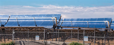
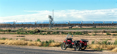
Leaving the museum, I stopped by the Solana Generating Plant, a solar energy concern on the road leading to the campsite. Unlike other solar farms I've seen elsewhere, there were using some different tech to collect sunlight:
There's a road called Sisson Road on the way back to the campsite. I motored down it to see what was there. Not much, but eventually the road is bordered by a canal of sorts which feeds into irrigation canals used by the local citrus farms.
As I neared the water, I scared up into flight a bunch of white birds with the sound of Scarlett's engine.
I was surprised, and stopped to get these pics of one of the birds. Egret?
The rest of the day was spent at the campsite, clouds moved in quickly and the forecasted rain is falling as I type these words. Supposed to only have a .06" accumulation but this campsite won't be affected in terms of mud/traction even if it turns out to be more accumulation.
The clouds of course prevented any views of the sunset.


6 comments:
The weather map shows a lot of rain west of here but that translates to only 0.06”. I remember going through Gila Bend around 40 years ago but don’t recall anything beyond the gas station. It was a hot drive in an old International truck. No A/C...
There’s not much there these days....it’s supposed to stop raining at 10pm. Forecast calling for more on Monday-Tuesday
I'd go with a snowy egret, Dom although the neck seems a little short.
This was the closest one I could get a pic of, and I couldn’t see their neck length as the others flew farther away....but I think you’re right SonjaM
The solar collector you saw is a parabolic trough collector with a tracking system. It is used to heat a fluid in the pipe at the focus. The hot fluid is used to create steam for power generation.
There is/was a small set of these just south of the Candelas development neat CO-93 and CO-72 called "Sky Trough" made by a company called SkyFuel (http://www.skyfuel.com/) that is based in Denver. That array you saw looks like it's one of theirs.
Thanks very much ScooterScum for the information re the solar plant’s technology....cool, never heard of that method.
Post a Comment