Friday, September 30, 2022

Wandering to Aspen Arch

Got some light to serious dirt trail riding done today.  The really technical spots were at the beginning and end of trail number 6037.  This is the trail that exits right next to my campsite.

In the technical sections, it was large boulders and rocks on a narrow twisting trail that made things interesting, sometimes too interesting, and I would have to put out my legs out as outriggers for balance.  

Surprisingly, I didn't drop the motorcycle once!

I was riding to find Aspen Arch, which showed up on Google Maps as I wandered about the area to the east of the campsite.  I had signal throughout so I navigated the trails using Google Maps.  Here's some of the views along the way, all using my Pixel 4a's camera as I'd neglected to bring along my camera case.


As I got closer to Aspen Arch, the hillside below is where its located, I spotted these curious vents on a couple of flat spots:

Maybe, they're air vents for secret government
bunkers eh?  ;)


I started using the COTREX trail maps app at this point to narrow down the location of Aspen Arch.  I was hoping to see it from the trail as I wasn't going to do the hike involved even if the trailhead was even marked!  BTW, I never saw a sign for the trail.
So, can you see the arch?

How about now?

My Pixel 4a camera at max zoom

OK, now you can see the arch right?

This is the best I could find in terms of 
Fall Colors on this ride.

Last pic before I got to the gnarly exit for route 6037.
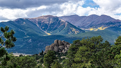
That's Turtle Rock over on the right.

It was blissfully solitary riding for the most part.  I did encounter a pair of SBSs (side by side) but they quickly disappeared with their noisy engines.  Their goal appeared to be to roar down the trail as fast and as noisily as possible.

I also came up on a couple of guys on dual sports and we chatted for perhaps a minute before I left them.  

Once I was back at the campsite, it was time to do a repair that had been waiting for a while now.  I went into town, to the local Ace hardware store, and got some needed items before completing the repair.

The task was to replace the worm gear and hex elevating shaft:

As you can see, the end had worn down quite a bit and the handle that came with the Wineguard TV antenna mast had come loose and would no longer turn the rod.

I had been using vise grips to grip the remains and turn the rod which would raise or lower the antenna mast with the Yagi antenna housing which I use for the Weboost cell signal booster.

The rod was a bit too long so I had to
Cut it where you see the black mark


Now, after failing to find a replacement handle with a quarter inch hex drive, I ended up with a $9 Hex drive wrench from the hardware store.

The jury is still out of course on whether the wrench will stay in place when the RV is moving about.

Still, I can still raise and lower the mast from inside the RV, so it's all good.

The weekenders have been entering the dispersed camping area all afternoon. The weather has turned rainy and it's supposed to be cooler tomorrow than today.

Thursday, September 29, 2022

Fall Colors on Cottonwood Pass and Cottonwood Lake Roads

 A great day of riding today, in spite of the overcast skies and the slight bit of hail at the summit of Cottonwood Pass.

But first, here's my view of part of the Collegiate Peaks (Mount Yale is the highest bit) from my VRRV's window as I ate breakfast:


I made a slight detour as I headed out to get a picture of the rock formation that is framed by the last tunnel (I think there's 5) that used to be a railway route near Buena Vista:


Just past the above rock formation is the Elephant Rock Campground:

Do you see the Elephant?

I then headed into Buena Vista, turning west on Main Street aka CR 306 which takes you eventually to the summit of Cottonwood Pass:

The requisite pic of the sign at the summit

The view from the summit, looking west

Ice Mountain


As one approaches the summit of the pass, there's some thoroughly enjoyable tight switchbacks:


Coming down off the pass heading back towards Buena Vista, I stopped where appropriate for some fall colors:


Taking every entry I could spot on the right side of the highway, I found some dispersed camping sites!  Lovely spots, though a bit tight for RVs, but there was cell signal!  They're right off the highway but the noise level is minimal as it's not a very busy highway.  I stopped below for lunch:


Here's a shot of the creek that runs to Cottonwood Lake I think:


Near Rainbow Lake Resort, there was a nice display on the hillside:


I turned into the road leading to Cottonwood Campground and found some nice Fall Colors.  

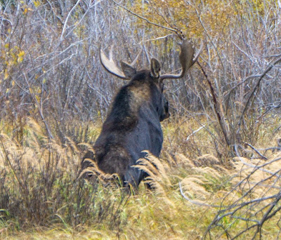
After I shot the above reflection shot, two ladies from Oklahoma stopped by Scarlett and informed me there was a moose up ahead!  I thanked them and headed to the spot.  I only saw one moose, but it was a big one.  Check out its rack.


The road continues for quite a ways after one leaves Cottonwood Lake and Cottonwood Lake campground behind.  I went as far as the road was graded and turned around at the sign that said: Limited Dispersed Campsites ahead.  You see, there's spots here and there along this road for boondocking!

No cell signal of course but still, some of the sites were definitely usable by the VRRV.  Perhaps the next time I'm in the area.


As I headed back towards CR 306 and Buena Vista, the clouds had really moved in and there was sporadic rain drops sprinkling down:


Made it back to town with no issues, got gas for Scarlett and filled up the 5 gallon spare gas can as well.  Paid $4.19 for the 97 octane, fuel is more expensive in town!

I might, if a sunny day comes along while I'm here, go back to Cottonwood Lake Road, the fall colors showed great potential but I fear the wind may cause a lot of the leaves to fall soon.

Wednesday, September 28, 2022

Now near Buena Vista, CO

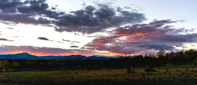
 Last evening's sunset colors:

I drove the VRRV, with Scarlett on the trailer, out of the Tarryall Dispersed Camping area just shy of 8AM.

I took the County Road 56 exit and boy that was a mistake!  The road was one long wash boarded dirt road all the way to the US285 highway!  Note to self, use CR 77 next time.

There was some construction going on which caused everyone headed to Buena Vista on US 285 to detour to US24 for a bit.  Still, made good time and no waiting at the propane reseller so I got to my desired camping spot by 10AM.

I left the VRRV holding down the spot and unloaded Yagi, my TW200, to recon the other boondocking sites nearby.  Sadly, none were better than the one I had already grabbed and the view from the initial site was the best.


Some hints of Fall Coloration in the Collegiate Peaks

My view of the peaks from my VRRV's window

As you can see, it was an overcast afternoon and it kind of tried to rain but no real precipitation.  

The plan is to hang out here a few days, check out both Cottonwood and Independence Passes and their respective Fall Colors.


Tuesday, September 27, 2022

Tarryall Day 5: Final Day - Wanderings

 Worry not, gentle reader, no overdose of Fall Colors today.  There will be more from latter camping sites, but from here no more.
I rode Yagi, my TW200, to the Cline Ranch State Wildlife Area to check it out.  It's located west of Jefferson, CO along US 285 and just west of the junction of County Road 34.

It was, disappointingly, a wildlife area seemingly dedicated to fishing.  It offers a four slot parking lot and you walk in to the "fishing beats", whatever those are.  The creek you fish from is Taryall Creek.

Still, it is land that used to be the Cline Ranch, part of the Tarryall/South Park Valley apparently.  Some old buildings remain and one can check them out.

Someone is trying to restore/preserve the buildings, but not to "historical" or authentic to period styling.  I think they're just trying to keep the weather out basically.

Here's a link to some historical info:  LINK

Main Ranch House


I liked the look of the horseshoe on the front door
of the cabin

I left the SWA without walking in further to check out the "fishing beats".

A couple of views from CR 77 where it goes over Michigan Creek.  


Riding back towards camp on CR 34, I stopped at the western end of CR 39 aka Rocky Hills Creek Rd which is the main access road to the dispersed camping sites.

From here, you get a good view of a nice and imposing rock formation which lies on private property:


That's it for the wanderings today, the rest of the day was spent reading and relaxing at the campsite as the skies turned gray and the day turned cool.  A little bit of rain (barely any) fell sporadically but not enough to even dampen the ground.

I'll be displacing to the Buena Vista, CO area tomorrow.  Not much else in this area that I wish to check out or see again.