Monday, August 31, 2020

Wyoming Boondocking - Days 4 & 5: Another Lazy Day and now near Buffalo, WY

 Sunday, Aug 30

Another lazy day of relaxation at the Bixby Public Access Area campsite on the North Platte River.

A very windy day mind you so not exactly a warm day, once the clouds moved in to block the sun it almost got chilly!

I did go riding with Yagi in the morning but only to meander about the BLM land near the campsite, same old scenery already shown to you so no pics were taken.

Spent the rest of the day reading, checking out the temporary reinforcements on the trailer, miscellaneous minor chores on the RV.

It would go down to 41°F (5°C) overnight so I made sure to have the extra blanket handy before I went to bed.  No need to run the catalytic heater!

Monday, Aug 31

Moving day.  Broke camp and was on the road a bit before 9AM.  Tried to dump tanks in the RV park at Glenrock but the office was closed till 10AM so I kept going.  

I made it to Buffalo, WY around Noon I think and found a free dump station at the Cenex Gas Station in town.  Good deal.  

Made my way out of town on WY Hwy 16 West, to find a place to stay near Buffalo.  Martha and I are checking to see how well General Delivery works with the USPS.  I'd forgotten some tools at home and she mailed them to me on Saturday, c/o General Delivery at the main post office in Buffalo.

The USPS website says the package has arrived so I'll be riding the 12 miles or so back to town tomorrow to retrieve it and check out the town as well.

Using the allstays app, I found a fee spot at the Tiehack Campground run by the National Forest Service.  No signal though which was a bummer.

Before setting up camp, I rode about 2.5 miles to get cell signal to let my family know my status and to activate the Garmin Inreach account so I could use my Inreach device for messaging in case of emergencies since I had no signal in the campground.

Returning to the campground in a light rain, I decided to check out a camping area on Circle Park Road near the Tiehack campground.  It turned out to be a dispersed (free) camping area and there were a couple of spots available!  Better yet, there was usable 4G signal.

I hurried on back to Tiehack campground, and since I'd already paid the $9.50 (Interagency discount due to my holding the American the Beautiful pass, regular fee is $19.50 a night), I was able to at least dump trash and top off the fresh water tank before displacing.

Got back to the Circle Park Road site and someone had beaten me to the really nice pull through spot! Oh well, the alternate worked out just fine.  It did take a bit of effort and maneuvering to get the URRV level but  now it's close enough for government work!


I had to deploy the antenna and use the weBoost device to be able to upload the above pics, downloading stuff seems fine.  Oh well, better than no signal!

It's supposed to get down to 34°F (1.1°C) tonight, and it's already 48°F (8.8°C) as I finish this posting so I'll probably run the catalytic heater tonight, on low, but still.

Saturday, August 29, 2020

Wyoming Boondocking - Day 3: NSTR

 NSTR: Nothing Significant To Report 

A very lazy day today for me.

The only riding I did was to a nearby spot next to the railroad where I could shoot the sunset with Yagi in the foreground.

Otherwise, I lounged about the campsite, reading and relaxing....quite enjoyable I must say.

In the morning, while eating breakfast, I chanced to look out the window and saw a local deer having its own breakfast perhaps 30 feet away from me:


It looks a bit gaunt, don't you think?

Besides the same boaters floating down the river and being picked up by pre-positioned vehicles here, I saw a man training his dog to fetch using something that looked like a fish.  Perhaps it retrieves fishes for him?  What caught my eye was they were both wearing matching camouflage vests.  :)

Definitely more visitors to this spot on a Saturday, but no one stayed long.

Even had a truck and small camper show up after 10PM last night, setting up in the dark closer to the Toilet Hut than I was.  But, they were gone this morning before I woke.

Sunset was OK, I was a bit late to catch the actual sun before it set though....was watching a couple of guy who'd shown up for evening fishing.  It's dark as I type this, and I can see then now setting up a tent near their truck with flashlights.  Oh well.


Friday, August 28, 2020

Wyoming Boondocking - Day 2: T-Dub'ing along the North Platte River

 Woke to a balmy 61°F (16°C) and the sun already above the horizon and trying to shine through the trees surrounding my campsite.

Just before 9AM, I left the campsite on Yagi, my Yamaha TW200 Dualsport to go exploring along Tank Farm Road towards the nearby Dave Johnston Power Plant.  I'd seen and heard the Coal Trains running by the campsite enroute to the power plant and figured it was worth a look.

First I checked out the Pacificorp Public Access Area, not much there but a parking lot and a boat ramp.  There is a nice bridge across the river right next to it though:

Bridge over the North Platte River

View of the river from atop the bridge

Shortly after the bridge, I came upon a good spot to pose Yagi, showing the power plant situated by the river:

Dave Johnston Power Plant

I turned around at this point as I realized I'd left without locking the URRV!  These senior moments are starting to occur more and more often!  I wasn't that worried but did want to ensure it was locked.

On the way back, I stopped several times to try and capture from ground level the remnants of what had caused this county road to be called Tank Farm Road.

From a satellite, Google provides this somewhat enigmatic view:

Kind of looks like very uniform set of bomb craters at first.
But it's all that remains of what must have been pretty large
petroleum storage tanks!

Best of several pics shot to try and capture one of the Tank Rings

Further along, I posed Yagi with this rusting sentinel of the Wyoming plains....


An overview map from the Bixby Public Access Area where I'm camping, to give you an idea of where I went:


URRV now locked, I rode onto a dirt trail through what appears to be BLM land and wandered on dirt tracks through grassy rolling terrain until the route I was on dead-ended on a ranch's locked gate.

Returning to the campsite, I spent the rest of the day just relaxing in the shade, taking the occasional cooling dip in the nearby North Platte River, and performing miscellaneous chores within and on the URRV.


I had discovered two pickup trucks, one of which was towing a large trailer, on my return and soon afterwards noticed several people with kids retrieving boats and inflatables from the river.  These same people would return in the afternoon, repeating the activity.  By this time I'd figured out this public access area is a good spot to float down river from wherever and then retrieve your boats and not have to paddle upriver.

There's a noticeable current on the river, so paddling would be hard work I imagine.

Right about the Golden Hour, I set out to ride the grassy rolling terrain nearby, and found a miniature version of Wyoming's Devil's Gate!  (The real one is unfortunately over 85 miles away)


To give you an idea of the grassy plains and rolling hills one can slowly ride and enjoy around here:


You can see where the river is....its where all the green is!

One last look back at the emptiness....

As I finish typing this, a couple of locals in a black pickup truck parked nearby apparently to fish.

Thursday, August 27, 2020

Boondocking on the North Platte River between Casper and Douglas, WY

 Enroute to the Bighorn National Forest this time, stopped at a spot I'd used before, the Bixby Public Access Area on Tank Farm Road (CR27) BLM site.

It's a small site but with level spots and I was the only one camping there tonight, we'll see how things develop as the weekend approaches.

It provides the public with access to the North Platte River and its cooling water.  A fact I took advantage of a few times this afternoon as it was quite warm!


I got there after 12:30 PM I think and was soon set up among the trees and trying to take advantage of the shade.

The sun's heat was somewhat ameliorated at times by heavy cloud cover and apparently the haze in the air from multiple small wildfires currently ongoing in the state!  Nothing as big as Colorado's or California's wildfires, but enough.

The map near the entrance shows several other public access areas along the river and I plan to check them out tomorrow.

A couple of bikers and their wives showed up in a couple of pickup trucks around dinner time and UDF'ed me for a bit about Fiona.

They then sat by their truck tailgates nearby and waited for the sunset, playing music on their truck radios but not too loudly.  Friendly enough people.

Sunset wasn't too bad but I was a bit late for it due to cooking dinner, still, not bad:


I am really glad I decided to come back to this spot.  There had been free spots (for one night and $15) an hour south on I-25 at the Glendo State Park but this place is "mo better", and free!  There is a five day limit on camping though but that's fine for my plans.


Thursday, August 20, 2020

Kremmling, CO - Day 6: Lazy Sunday and home on Monday

 Sunday, August 16

Did some riding of the hills near the campsite, but didn't range very far.  Ended up on top of a steep hill, after miles of easy trail and made it down successfully though not without trepidation.

Even in first gear and gentle use of the brakes, Yagi picked up more speed than I liked, but we made it down just fine.

Very hazy due to the forest fires to the east:

Spent the rest of the day just hanging out at the URRV, listening to an audio book and trying to stay cool.

Monday, August 17

Broke camp and came home, I'd seen all I wished to see this trip around Kremmling, rode what I wanted to ride and the campsite area was beginning to fill up with more people.

Note: There seems to be a growing trend of people setting up a tent at a camp spot to "claim it" but  then not use it for days on end.  Reminds me of the seemingly unused travel trailers set up in spots near the dispersed camping area south of Jefferson, CO.  Same objective but with travel trailers.

What do you think of such a move?

Got home with no issues, to 92°F (33°C) and sunny skies in the cesspool that is the Metro Denver area.  I'll be cleaning up the URRV, trailer, gear and such over the next 72 hours during which I'm allowed to park my RV in my own driveway.  This is a restriction, undocumented that I can tell, haphazardly enforced by the HOA management company.

Good trip overall, nothing major broke, had some good rides and relaxing times for the most part.


Wednesday, August 19, 2020

Kremmling, CO - Day 5: T'Dubing the trails near Wolford Mountain, the Heritage Park Museum and Mushroom Clouds

 Saturday, August 15

Woke to a crisp 40°F (4.4°C) morning temperature, pretty much the same as the last few days.  Not sure why it's colder here at night than Independence Mountain which is about 2000 feet higher in elevation!

A leisurely breakfast as I waited for outside temperature to break 50°F (10°C) so I would only have to wear my riding jacket liner under my regular riding gear.

Yagi and I got on County Road 22 north and were soon exploring the trails branching off from County Road 25, farms and ranches to the east and Wolford and Little Wolford Mountains to the west.

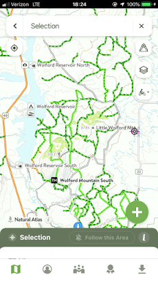
The above screenshot from COTREX app show the many trails available for dualsport riding.

Found some nice campsites with great cell signal but getting to them could be iffy with the URRV.  Still, I recorded the ones I liked in my PocketEarth app and just kept on pootling around.

I believe that's Little Wolford with Wolford Mountain in the far background


A distant view of the Wolford Mtn Reservoir
Pretty hazy conditions due to the ongoing fires in the state


Now further east of Wolford Mtn
Looks like some idiot dumped a Spin Cycle Exercise Equipment

Eventually, I ended up back on County Road 224, near where I am boondocking.  Yagi and I rode up a nearby hill for the views:


Can you spot Umarang?

After lunch, around 2PM, I decided to check out the local Heritage Park Museum in Kremmling.  Since I'm an old guy now, it only cost $5 for admission.  Not much of a discount as the adult fee is $6 but hey.

Not too bad a museum, spread out among several small buildings, the exhibits are what you'd expect of pioneer life in Middle Park, the area where Kremmling is in but also included exhibits/photos/displays on specific subjects such as a brief history of the Forest Service.  One starts at the Homestead House and then moves on to the other buildings.

Here's some of the things that caught my eye:

Ranger Station

you don't see want ads like this anymore....

I didn't know that a Fedora was the original hat
for the Forest Ranger uniform.


The Town Jail was basically a small cabin, with pictures of towns folks and events....not much in terms of prisoner memorabilia or such.


I thought this was a cool old picture of the Kremmling's Cliffs
which I dimly recall was one of the items posted inside the jail....

The Smithy's building's facade still exists, but it fronts the open air
portion of a cafe now, and there were too many cars in front for
me to get a decent picture of it.

Between the Town Jail and the old Railroad Station, was this mystery machinery....no signs/documentation, but I figure it involved lots of grease and probably some big hammers to operate!


The RR Station is currently closed for restoration funds and work.

Inside the visible portions of the Train Station, this old car....

Next up was the Livery and Feed Building.
Here's Yagi parked in front.

Same building, back in the day....

A saddle with two horns?
No documentation seen.

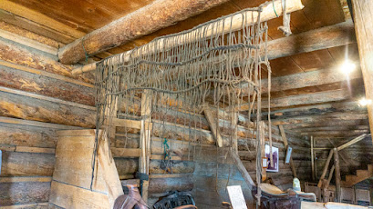
Some of the old time smithy's tools....

What the heck is that net-like thing I wondered....

The answer, surprised me....pretty
sure it didn't catch on.....

Homestead house and museum HQ

Leaving the museum, I posed Yagi at a spot showing the town's view of the cliffs:


Then, seeing the smoke from the nearby (19 miles by car) forest fire in Sulphur Springs, I rode Yagi to the top of the cliffs for a shot:


Riding back down from the edge of the cliffs, I checked out this trail and found a nice overlook spot for Cow Gulch and what seems to be a nice but sloping camping spot:

Overlooking Cow Gulch with Wolford Mountain in background

I then rode down to Cow Gulch's picnic area, found it being used by a family so instead I decided to check out this narrow trail leading out of Cow Gulch and according to COTREX heading towards Wolford Mountain.

I ended up riding down the trails that I elected previously to not ride up as they looked too steep!  Oh well, soon I was back on CR 224 and headed back to the campsite.

The rest of the afternoon was spent cooling off and processing pictures and such.  Oh, and there was no longer a need to ride to a high spot to see the forest fire's mushroom cloud, it was easily visible from camp:


After dinner, I saw the setting sun painting the highly visible smoke mushroom cloud with some interesting colors:


As I type this, it's dark outside but there's a visible red glow on the horizon to the east where the fire continues to burn.