But then, they talked about Chuckles, another weather predicting groundhog in Connecticut, and this one saw his shadow, thereby predicting six more weeks of Winter!
Slightly amused at the amount of coverage devoted to rodents and their shadows, I headed out for a ride into the mountains instead. We'd had some snow recently and I was hoping for some good views of snow-capped peaks you see.
I crossed the Denver Metro Area, in slightly heavy traffic for a Saturday morning, and used US6 off of the I-25 Super Slab to get to the city of Golden. From there it was once again riding north on CO93 until its junction with Coal Creek Canyon Road or CO72.
The objective again today, was to achieve that photo of the view of Gross Dam that I'd seen while motoring on Gross Dam Road over a couple of weekends ago in the company of stalwart and only slight frozen Uralisti. LINK There had been no chance for a photo that day you see, and a recent attempt on Brigitta, my '87 R80 Airhead Beemer had resulted in failure.
As I was on Valencia, my 2011 Ural Patrol, there was little concern on my mind about the loose gravel, snow and ice that I'd found the last time. Again I turned onto Crescent Parkway which eventually reaches a T Junction, the right turn off of which is Gross Dam Road.
Up and down the dirt road we went, snow and ice of no concern and only slowing for the hair pin turns where the dirt road had become heavily washboarded. At these spots, the rig bounced and fought me, but eventually we'd be past the bad stretch of road and back on relatively smooth dirt. Pretty soon I was at the now familiar railroad crossing, and this time I went further along the train tracks to a spot where I could get a nice shot of a distant peak:

You can get a nice vista of Gross Dam from here

Motoring onwards, I went with ease past the snow-covered curve which had stopped me when on two wheels this past weekend. It was just a short distance from that point (how close I was the last time) that I got to the spot with the view of Gross Dam:

Gross Dam
Continuing onwards, it was a short distance to where the road once again forms a T. The sign to my front said I'd get to the "North Shore" if I turned left and to the "South Shore" and Boulder if I turned right. I turned left and discovered an open gate, with signs saying that boat ramps and picnic sites were ahead! Here I'd been thinking the way would be locked. These post-911 day being what they are, most dams I've seen are secured and difficult to access. I was pleasantly surprised and enjoyed the smooth dirt road up towards Windy Point.

Turns out, you can get pretty close to the actual dam, though still, you cannot not ride upon it as the way is barred by fencing and a pretty sturdy gate.

Here's a view of the reservoir's waters, portions of which are frozen over.

Here's Valencia at another point on the North Shore, where the boat ramp is located although it is closed to boats until Memorial Day Weekend.
 Look in the distance, see those two dark specks on the ice? It's ice fishermen!
A closeup view, at max magnification of these hardy ice fishermen. I didn't think the ice was strong enough for people, it sure didn't look like it from the shore.
One last view of the reservoir from the area of the boat ramp at Osprey Point.
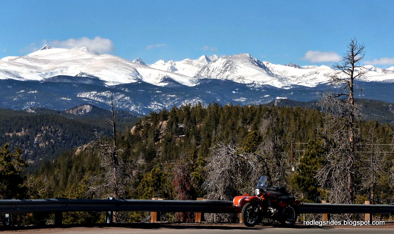
I retraced my path back towards the T junction and pointed Valencia back the way we'd come, heading back towards CO72. I was enjoying the surefootedness provided by Valencia's three wheels, negotiating the gravel filled hairpins with ease and soon I was stopped by this view:

A view of the front range from Gross Dam Road
Soon enough we were once again back on CO72, twisting our way through the canyon walls carved out eons ago by Coal Creek. The weather continued to be a bit cool, with temperatures in the 40s but with the bright sun warming things up nicely. We reached the aptly named town of Wondervu before much time had passed and I spent some time posing Valencia alongside the steeply twisting and turning roads to the west of the town.
Nice peak views near the town of Wondervu


One plunges down twisting pavement down into a valley after Wondervu, the next town is Pinecliffe where the railroad bisects the road. Before one gets to Pinecliffe however, there's another set of steeply climbing and falling turns to keep one amused.

A view of the peaks between Wondervu and Pinecliffe
A few miles past Pinecliffe, we arrived at the junction with the Peak to Peak Highway portion that is CO119 and turning southhward along this two lane highway, we sought the small town of Rollinsville, two miles away.
At the border of Boulder and Gilpin Counties, there's a lake I tend to stop at for a picture:
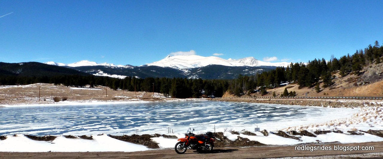
Small lake between Rollinsville and Coal Creek Canyon Rd on CO72
Rollinsville is the eastern end of the Tolland Road, a.k.a. Rollins Pass Road. It leads one to to the eastern end of Rollins Pass Road and also the eastern portal of the Moffat Railroad Tunnel. It would be cool to someday ride a train that traverses this tunnel that crosses under the Continental Divide.
Tolland Road was mostly clear of snow though there were a couple of stretches where there was enough snow on the road to make things interesting. No issues for Valencia of course and I didn't even have to engage her 2WD capabilities. As I got closer to the settlement of Tolland and the Moffat tunnel entrance, the views of the Continental Divide's peaks got quite nice:

View of the Divide, before the settlement of Tolland

Past Tolland and the turn for Mammoth Gulch Road, a closer
view of the Continental Divide

The usual shot of the Moffat Tunnel's East Portal.
Links to youtube videos showing trains entering and exiting the Moffat Portals:
Amtrak Trains and the Moffat Tunnel
What does it look like as you exit the tunnel? Fast forward to 1:40.
Links to youtube videos showing trains entering and exiting the Moffat Portals:
Amtrak Trains and the Moffat Tunnel
What does it look like as you exit the tunnel? Fast forward to 1:40.
Sometime soon, I must gather some Uralisti together to try and ride the western side of the Rollins Pass Road. You can reach the summit sign from the west sign you see, the way is barred from the east side as the Needle Eye Tunnel has been closed for many years due to dangerous conditions and cave-ins.
This time, I walked along the hiking trail to the right of the tunnel entrance, which borders the railroad's property. From the viewpoint of the picture above, it seems like there's no tunnel into the mountains doesn't it? It appears the trains must start descending down into the earth shortly after entering the tunnel entrance! I could see concrete structures with large fans venting air out, leading the eye into the earth. It surely must be some ride, that tunnel.
I got back on Valencia after waiting for, hoping for, a train to exit the tunnel. No train appeared, I must find a schedule of their transit of the tunnel for future rides. Valencia and I retraced our riding back towards Rollinsville, enjoying once again the two stretches of snow-covered road.
I proceeded on CO72, heading now towards the gambling towns of Black Hawk and Central City. Transiting both, I soon was on the Central City Parkway making my way down towards its junction with the I-70 Super Slab.
The rest of the ride was boring slab riding all the way back to the US6 exit off of I-70. I-25 southbound led me to the University Boulevard exit which I used to get to Evans Road and the local motorcycle accessories shop I like. I picked up a tire valve stem fishing tool and then headed on home via city streets.
A good day's riding, with temperatures never dipping much below freezing. Heck it was almost 60°F by the time I was near home!
I hope you liked the pictures, hopefully you were able to get out on your motorcycle of choice and get some riding in! Such a mild winter we're having so far, I think Punxsutawney Phil might be right, but I am hoping that Chuckles proves us both wrong.
Previous post: Carrying Spare Fuel on Valencia
2 comments:
What a divine scenery especially the vistas from Wondervu.
I saw a Ural today at our Yamaha dealer, I wanted to check it out but hubby was too busy driving by...
By the way, Willie, the Canadian groundhog counterpart is siding with Phil. I don't mind. May it be Spring now! Winters at the Wet Coast suck, the snow is slush and people can't handle it anyway.
Thanks for the kind words SonjaM, you'll have to get your hubby to slow down next time....
Post a Comment