Today I was riding Brigitta, my 1987 R80 Beemer who handles dirt roads much better than big Maria, my 2004 R1150RT. Maria is more into "continent crushing riding" while Brigitta has allowed me to explore some of less paved areas in the foothills of the Rockies.
I crossed the Denver Metro Area using the I-25 superslab to get to the US6 slab westbound to Golden. At Golden I tanked up and then headed west on US6, enjoying some nice twists and turns on that two lane road which winds its way through high rocky canyon walls. Traffic was light so before I knew it, I was at the junction of US6 and CO119 which I got on to get to the gambling town of Central City.
I meandered through this little town, whose sole industry is apparently the liberation of money from gamblers, and soon found a sign leading south out of town. I was then on the Central City parkway for just a bit when I spotted the sign for Nevadaville.
This road soon became dirt and while rocky and gravelly, no big deal if one takes it slow. In less than an mile, I came upon the remains of the old mining town of Nevadaville. One of the Colorado gold rush towns of the late 1800s, only a few buildings remain of what at its peak was a town of almost 4000 souls. Ghosttowns.com's entry has more pictures of this ghost town. LINK
Here's more historical info on Nevadaville: Google LINK
 I bebopped right through town after the above picture, wanting to see what lay on the other side. I wandered up on Bald Mountain Road for a while, ending up turning back towards Nevadaville when I found no scenic views to photograph on that road.
 The best preserved mining structure I found, note the tailings left from the old mines, these dotted the hillsides around Nevadaville
 The larger of the two buildings is the Masonic Lodge #4, still in commission apparently. The building with the three arched doorways used to be a saloon back in the Gold Rush days. Now it houses a small antiques shop.
 City Hall, as seen from the corner of the Masonic Temple
 After I left Nevadaville, I made my way back to the Central City Parkway and headed South towards Idaho Springs, in search of the "Oh My God" road. The Central City Parkway, it should be noted, is a nicely paved four lane highway with some nice sweepers and a few twists that are rather enjoyable. Just watch out for the law.
Once at Idaho Springs, after a short sprint on the I-70 superslab, I made my way up and down its main street looking for a sign for the "Oh My God" road. Not finding one, I wandered up the Virginia Canyon Road as it looked familiar and came upon what I remembered as the start of the "Oh My God" road.
Funny, it didn't seem as forbidding as the last time I was there. Sure, its steep and rocky and there's no guardrails but it looked highly doable. I didn't even stop to take a picture or hesitate, I just kept on riding up Virginia Canyon Road which I believe is also called the "Oh My God" road.
 Map of my wanderings today
Note: for the locals who read my meanderings, if I got this road mistaken, please let me know. I could not find another road heading North out of Idaho Springs but could have missed it I guess.
The first mile is a bit challenging with plenty of smooth rock outcroppings sticking up an inch or two from the packed dirt surface. Lots of gravel of course but it all becomes just packed dirt with pea-sized gravel in no time. The only parts I didn't like were the occasional section of road that had become washboarded. I'd have to rise up off the seat and use my knees as shock absorbers to negotiate these patches, but in the end, they too were no big deal.


The road and the scenery it offered were pretty much unremarkable, lots of hairpin turns as the road ascended, hugging the side of the mountain. The views of the terrain below, whenever I stopped for pictures, must have been what caused this road to be called the "Oh My God" road. The dropoffs were quite steep I'll admit.
Eventually, I happened on the ghost town of Russell's Gulch. Another gold mining town, it was founded by William Green Russell in 1859. As with Nevadaville and countless other mining towns in Colorado; the town of Russell's Gulch lost its population when the gold in the nearby mines ran out or became too expensive to mine. All that remains are a few crumbling walls and foundations, with newer homes dotting the hillside. These "newer" homes bear the weather-worn look of the town as well.
 The crumbling stone foundations are what remain of the many houses that existed in Russell Gulch back in the late 1800s
 The only building that seemed to fit the town's beginnings when I rode through.
I left Russell Gulch and neglected to take a closeup picture of the old schoolhouse, it looked abandoned, with all its windows broken and doors boarded up. Here's one I found on flickr:
 Courtesy of: coloradobulldogs
 Courtesy of: coloradobulldogs
I left Russell Gulch behind me as I continued on Virginia Canyon road. This eventually dropped me off near Black Hawk, another gambling town located next to Central City.
 Black Hawk
Both these towns have gone to some pains to refurbish the buildings within their limits. The results are picturesque facades which try and transport the tourists back to the towns' heydays of the late 1800s I think.
Not being a gambler of this sort, I did not tarry as always. I did stop though and get this picture of this restored locomotive for Jack Riepe, who publicly professes in his blog of being fascinated by trains. Here you go Jack:


I left Black Hawk behind me, cruising eastward now on CO119 and soon afterwards on US6 heading back towards the town of Golden. I'd spotted a turn off for Douglas Mountain Drive on the way to Nevadaville earlier in the day; and so I took it off of US6 and wandered up this dirt road to see what I could see.
It turned out to be a mountainside-hugging, hair pin curves filled, but not much in the way of scenic views. I got all the way to the top, turned around as the road lead to Golden Gate Canyon Road and I did not want to go there today.
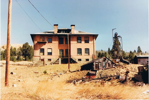
As I made my way down Douglas Mountain Drive, I spotted this house on top of a small hill, with part of the road framing it, figured it was worth a shot.

As you can see, the bright sunlit skies I'd enjoyed in the morning were now overcast skies. The clouds cast a pall on the rocky terrain around me as I cruised back down the mountain and eastwards on US6 and its rocky canyon walls.
The rocky walls, which had looked so brilliant in the morning, were now dull and didn't cause me to stop much for pictures. Still, I managed a couple more shots, which give you a slight idea of the terrain around me.
 On the East side of tunnel #2, US6, Heading towards Golden
 A view of Clear Creek, which borders US6, from the east side of Tunnel #1
 Black Hawk
Not being a gambler of this sort, I did not tarry as always. I did stop though and get this picture of this restored locomotive for Jack Riepe, who publicly professes in his blog of being fascinated by trains. Here you go Jack:


I left Black Hawk behind me, cruising eastward now on CO119 and soon afterwards on US6 heading back towards the town of Golden. I'd spotted a turn off for Douglas Mountain Drive on the way to Nevadaville earlier in the day; and so I took it off of US6 and wandered up this dirt road to see what I could see.
It turned out to be a mountainside-hugging, hair pin curves filled, but not much in the way of scenic views. I got all the way to the top, turned around as the road lead to Golden Gate Canyon Road and I did not want to go there today.
As I made my way down Douglas Mountain Drive, I spotted this house on top of a small hill, with part of the road framing it, figured it was worth a shot.

As you can see, the bright sunlit skies I'd enjoyed in the morning were now overcast skies. The clouds cast a pall on the rocky terrain around me as I cruised back down the mountain and eastwards on US6 and its rocky canyon walls.
The rocky walls, which had looked so brilliant in the morning, were now dull and didn't cause me to stop much for pictures. Still, I managed a couple more shots, which give you a slight idea of the terrain around me.
 On the East side of tunnel #2, US6, Heading towards Golden
 A view of Clear Creek, which borders US6, from the east side of Tunnel #1
Once I reached Golden, it was just regular riding on slabs. Back across the Denver Metro Area using the I-25 to I-225 slabs to the Parker Road exit.
A total of about six hours of saddle time, 160 miles total of riding. Pretty good ride, the weather was warm....ranging from the low 50s around 10am to a high in the low 70s by 4pm when I got home.
A total of about six hours of saddle time, 160 miles total of riding. Pretty good ride, the weather was warm....ranging from the low 50s around 10am to a high in the low 70s by 4pm when I got home.
4 comments:
Awesome pics, thanks for taking us along!
-Peace
Great stuff! I've long been wanting to do a tour of ghost towns, this only helps to motivate me into action!
Makes me want to go to the library and start checking out history books!
Who would have thought you could use an old R80 as a dual sport?
Allen and Clark, thanks for the kind words.
Irondad....dualsport? a very slow dualsport!
Post a Comment