Saturday, January 11, 2020

Another errand, another view of Picacho Peak and Varmints in the camp

Friday, January 10

Left camp soon after 7AM to ride Fiona, my '99 Ural the 30 miles to the Ina Road Harbor Freight Tools in the northern portion of the Tucson Metro area.  I was exchanging the solar panel set I'd just exchanged on Thursday as it had not worked out of the box!

Boy, it was cold riding in the early morning darkness, waiting for the sun to come out and warm things up a bit.  I found myself warming my gloved hands on Fiona's engine's jugs, one hand alternating with the other on the throttle to keep going.

To their continued credit Harbor Freight didn't even ask a question, simply did the exchange paperwork and I was out of there in less than 10 minutes.  This time, I deployed the panels in the parking space used by Fiona and ensure everything worked before packing it all up and uraling it all back home.

Rest of the day was spent setting up the new panels and monitoring their workings.  I'd been operating under some wrong assumptions re the charge controller.  Bottom line, you really can't force a charging mode, it'll do it its own way. 

Once the panels were set and charging the URRV's house battery; I took Fiona on a different errand to the Shell Gas Station on Picacho Peak Road and filled up both Fiona and the 5 Gallon spare gas can.  Also picked up a small one gallon gas can for Yagi's use, since I keep leaving the one I have back home in the garage.

Prior to returning with Fiona and the gasoline, I stopped near the junction of the eastbound side of the I-10 Frontage Road and Park Link Road and got these pictures of Fiona:

 Picacho Peak


Relaxed the rest of Friday at camp.

Here's a view of Friday's sunset from inside the URRV:


Saturday, January 11

Warm and sunny, though still quite brisk on Fiona as it was only in the mid-40s when I rode out east on Park Link Road to check out the sights at the Catalina State Park.

Saw a sign pointing to the Biosphere 2 project under the University of Arizona so I detoured the six miles to see if I could pose Fiona with it's interesting looking buildings in the background.  No such luck, its situate in such a location that you have to pay the entry fee ($14) even if all you want to do is take a picture.

So, here's a picture of a poster sign outside the entrance:


Fiona and I then headed down towards Catalina which turned out to be basically strip malls, big box stores and nothing at all picture-worthy in my mind.  The nearby Catalina mountains were not being lit well by the late morning sun and so I kept going to the city of Oro Valley.

Nothing but another mess of "civilization" with clusters of houses cluttering up the hillsides of the nearby mountains.  Again, no pictures.

Heading back North, finally stopped and paid the $7 fee to enter the Catalina State Park.  The mountains within seemed promising but again, no pictures.  It's basically another hiking park and its proximity to Tucson and it being a Saturday meant the trail head parking lots were jammed with cagers.

So, I left soon after and retraced my route back to the BLM camp area. 

Puttered on Fiona for a bit, she keeps blowing a fuse which affect the ignition system but found no bare spots on the wire involved with the fuse that keeps blowing.  The wire is the one that provides 12 volts to the ignition key assembly so perhaps something under the tank? 

Rest of the day was spent enjoying the sun, reading my e-book and watching the varmints that live by my campsite. 


I shot the pics of the varmints with the telephoto lens from within the URRV, am pretty sure they would have rushed into their underground homes if they'd seen me walking near them.

Thursday, January 09, 2020

Errands Day and some Light T-Dubing

Wednesday, January 8

An errands kind of day.  Got groceries, exchanged the Harbor Freight solar panels for a replacement set as the charge controller had quit working.  The new set has a faulty splitter cable so now have to return that one as well, but not that day or Thursday. 

Also visited a hardware store to get a replacement M12 x 1.25 Nyloc nut to replace the non-nyloc nut that had disappeared from the upper front mount point for the sidecar frame on Fiona.  No issues, just a slight rattle that had me puzzled till I found the nut to be missing while checking the routing of the throttle cables on Fiona.

It had been a gloriously warm and sunny day too.  Oh well.

Thursday, January 9

A not sunny and heavily overcast day for the most part.  The sun did shine through on occasion but only briefly and we're expecting some rain this evening as well.  Due to the cloud cover though, the sunrise was pretty nice:


Rode Yagi, my Yamaha TW200, on some of the dirt trails criss-crossing the BLM area that I'm camping within.  First stop was some rock formations I'd seen from Park Link road which turned out to be accessible from Owl Head Ranch Rd right off Park Link Road.  I found this road by traversing several miles of narrow dirt road instead, dodging the occasional chola cactus spiny cluster on the trail.

Got to the rocks which are apparently known as Owl Head Buttes and found an abandoned house and stables structures near the base of one of the buttes which had drawn me there.  Kind kind of eerie so I didn't tarry.


None of the buttes seemed like an owl head to me while I cruised about the ranch's vicinity.  The ranch is now within AZ State Trust land but no signage explaining anything.


Continuing to explore BLM trails, found some more area to ride in across Park Link Road (it was an OHV tags required area so I didn't go deep into it.)  I did stop at a small rocky hill, walked up and got these pics:

 From the small hill, you could see the Owl Head Buttes

 I think perhaps the rock formation on the right is the Owl Head?


I also meandered over to the extreme eastern portion of the BLM area I'm camping within and found several informal spots where people go and shoot firearms, using a small hillside as a backstop for their rounds.

Not much to report, just lots of cacti of both the Saguaro and Cholla varieties, lots of scraggly bushes along the trails, lots of sandy spots to get your attention and cloudy skies.

Wednesday, January 08, 2020

Uraling to Picacho Peak and ironwood Forest National Monument

First sunrise from the BLM campsite near Marana, AZ


Soon as temperatures got into the mid 40s, I geared up and rode the 16 miles or so to the Picacho Peak State Park as the morning light was highlighting it nicely:


I should have researched it a bit more because, the park is basically a hiking park in that what roads do exist are to either lead you to trail head parking on the campground.  Note: the campground appeared more than 3/4 full as I rode by.

Picacho Peak, imposing and eye-catching from a distance proved a bit less impressive close up.  I didn't spend a lot of time there as the light from the sun was all wrong for pictures of the mountain from within park boundaries.

The pictures I took from nearby Rooster Cogburn Ostrich Ranch (Yes, Ostrich Ranch where you can also feed Manta Rays) proved "meh".  Nope, didn't go in to check out the Ostriches or the Manta Rays.

Looking to the west, I saw an interesting rock formation in the distance and so I made my way to the bedroom community of Red Rock and took Sacos Road west seeking to close with that rock formation.

Many miles of dirt, rocks, gravel, dips and ruts later, I reached the junction with Silverbell Road.  I took this south for a bit to get me closer to the rock formation and I found myself close soon enough.

Found a trail off Silverbell Road which lead to some really small dispersed camping sites (barely room for a car and a tent) surrounded by many Saguaro Cacti.  Turns out I'd accidentally strayed into the Ironwood Forest National Monument.  A destination I'd planned for this week but not today.  Oh well.

Parked Fiona at one of the small camping spots and took off my riding gear to hike in closer to the rock formation in question:

Less than a mile later:


 The highest peak is Ragged Top and second one is Wolcott Peak
according the the PeakFinder App.


Once I rode out of the dispersed camping spot, I turned south on Silverbell till it with another road, and found a spot for this picture of Ragged Top:


Further progress on this particular road was barred by a gate so I turned back to Silverbell Road and rode it back to civilization.  By this time, I was running low on gas so I rode back towards Red Rock, a brief stint on I-10 (very busy traffic going very fast) and finally got back on the frontage road that leads one to Park Link Road. 

I rode back towards the state park where I'd seen a Shell Gas Station and fueled up.

On the way back to Park Link Road, atmospheric conditions looked good fro the mountains to the west so:

The formation on the right was what attracted me earlier in the morning
as I left Picacho Peak State Park


It was after 2:30 PM by the time I got back to the campsite and had a late lunch.  So no more riding today, two "day events" in one day....a bit tired.

The place is getting crowded, I can almost see my next door neighbor's motorhome through the cacti and bushes!

Here's the second sunset:


This shot of Picacho Peak was from the roof of the URRV, not too shabby
when using Sunset Mode in the camera.


Monday, January 06, 2020

Now boondocking on BLM Land near Marana, AZ

Displaced from the Buenos Aires NWR this morning, having explored what I wanted to explore in that area for now.

I took a 14 mile detour on the way to Robles Junction to check out the Caballo Loco Ranch's RV park to empty tanks and take on fresh water.  It's 7 miles of dirt road, sometimes washboarded, but not too bad to get to the ranch; but there were more RVs there than I figured.

Apparently, its one of those repeat customer sites so there must be something going for it eh?  I might check it out next time I'm in the area as a week at a dry camping spot is only $77 and you get access to such stuff as laundry, showers, dump station and water.

I also got propane before I left, and made my way via GPS to the Marana, AZ area, bypassing the Tucson metro area by avoiding the use of I-10.

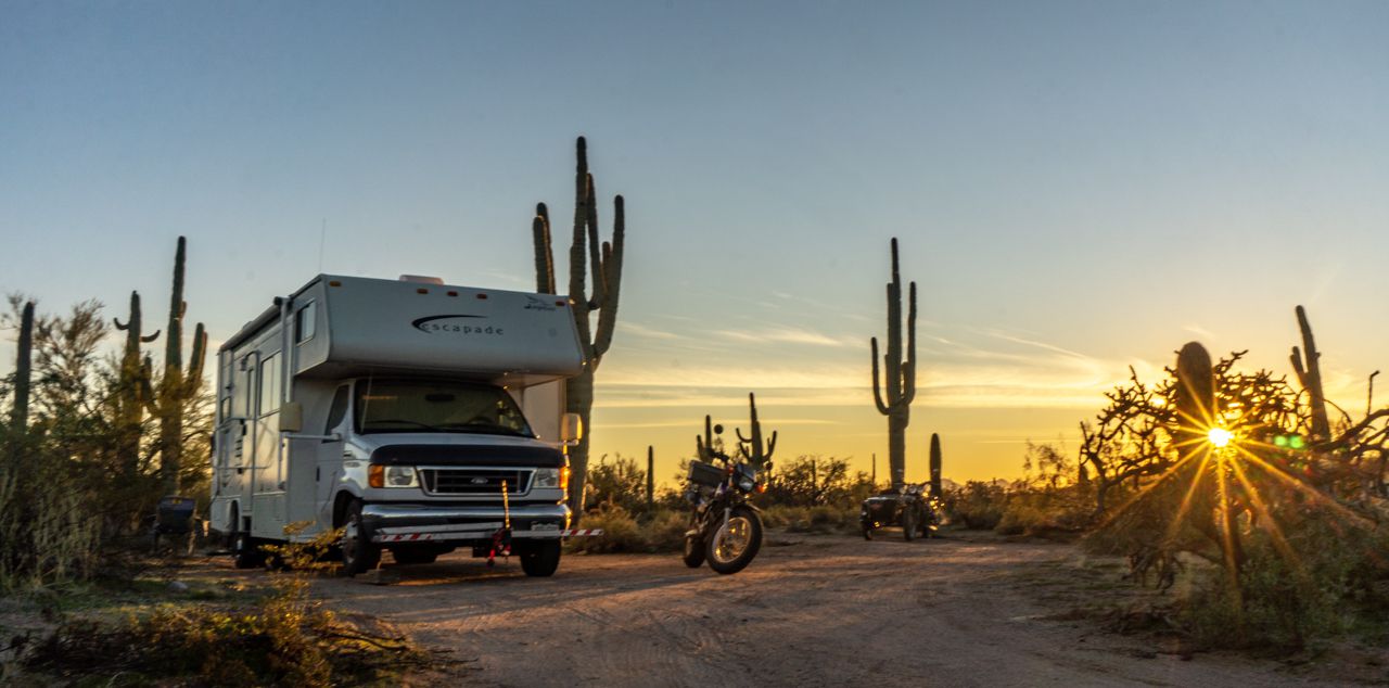
Got to the site in the early afternoon, the place is set in the middle of a forest of Saguaro and Teddy Bear Cholla Cacti.  The sites are pretty small for the most part from what I've seen so far but I managed to snag a cozy site for the URRV:


By the time I got camp set up, it was almost 3PM so no riding today besides the little bit I did on Yagi to explore the potential for campsites before selecting the one I had originally parked beside.

 Picacho Peak from the campsite

Distant peaks in shades of blue

Sunset was pretty pretty much clear skies but the Saguaro Cacti silhouettes made it all better.


Going to spend a few days in the area, there apparently are several interesting areas to explore, to include of course Picacho Peak!