Wednesday, February 14, 2007

New Farkle for Maria

So, second day of snow, no riding for me or Maria again. Light snow this time, the sun was out during the morning and did a really nice job of melting the snow somewhat. Right now its falling lightly but not sticking, its 1630hrs, so hopefully it'll stop soon.

A minor piece of farkle showed up in the mail from iliumworks. It's an extension metal piece for Maria's rear brake. I've found myself twisting my right foot inwards, sometimes uncomfortably like at stoplights so I decided to try this $20 extension to see if it helps me engage the rear brake comfortably without me accidentally hitting it while riding.


The instructions said to drill a hole into the brake pedal to mount it securely, I chose not to do that. Instead I used some friction tape and its holding it onto the brake pedal quite tightly. I am pretty sure it won't come off, and if it does, it's just $20.

Additionally, I'd been shopping around for a small but cheap air compressor I could carry on the bike in case of a flat tire. One that I could use in lieu of the CO2 cartridges that comes with the Beemer tire repair kit to reinflate a tire after repairs. While googling such a piece of kit, I ran across this article on webbike world.


The article describes how to take apart a plastic encased air compressor and use its "guts" as your "compact" air compressor on a bike.

Dang if I did not have an old Coleman air compressor that once I took apart looked very similar to the one in the article! Got it wired up and tested it by releasing a few pounds of pressure off the front tire on Maria. It worked beautifully, slowly but capably inflating the tire back to the 42 psi recommended by the dealer. Now I have an air compressor with me to help me repair a flat tire and who knows what else!

Saturday, February 10, 2007

Seeking the Sangre de Cristo Mountains, found the Spanish Peaks instead.

Temps ranging from 40s to 30s to 50s. Mostly sunny, fog in one valley, overcast skies.

[removed previous commentary re stupid neighborhood kids and their mom, no sense clogging up a riding blog with them]

So, that unpleasant beginning aside, I rode on down to the I-25 super slab and cruised at about 10miles over the speed limit of 75mph, through Colorado Springs and then Pueblo. My destination was to take a picture of the motorcycle with the Sangre de Cristo mountains in the background. Once I cleared Pueblo I could see an approaching bank of what I thought as first to be smoke from a forest fire. It turned out to be fog of all things, cold wet fog. The temps dropped very fast from the low 50s to the high 30s and I was freezing! I stopped at an exit called Stem Beach and donned long underwear shirt and my electric heated vest. It was even cold enough that I mounted the QuadBoss covers on the handlebar grips! After that, I was nice and toasty and set off heading South again.

Of course, soon as I had all the gear, I cleared the area covered by the fog bank and was able to once again ride in the full light of the sun and temps back again in the low 50's. I made pretty good time, turning off I-25 near Walsenburg which I cruised through and then took CO 160 West towards what I thought were the Sangre de Cristo mountains which had been visible just a little bit after clearing the fog bank south of Pueblo.

Spanish Peaks from just South of Apache City
Stayed on 160 and headed toward La Veta, a little bitty town that sat close to what I thought again were the Sangre de Cristo Mountains. Turns out, I was wrong, should have broken out the map when I stopped West of La Veta to take pictures. Here's Maria with what turns out to be The Spanish Peaks in the background.

This is the closest we got to the Spanish Peaks

I left La Veta and headed back North towards I-25, on the way back to the super slab I was able to pose Maria with another shot of the Spanish Peaks.


To the North of La Veta I had also seen this great range of Mountains which I had mistakenly taken to be the Spanish Peaks, these turned out to be The Wet Mountains. Yep, that's what the map says. Part of the San Isabel National Forest.


One last shot of the Spanish Peaks

I got back on I-25 and sped North so I could get home before dark and water started freezing again. The trip back was uneventful, I once again endured a cold spell through that cold pesky fog bank south of Pueblo. What a miserable area to live in that must be. I had stored away the handgrip covers for the return trip but the electric vest kept me warm enough until I cleared the area.

I got back home by 1630, safe and sound and just a bit chilled. Got Maria gassed up, had stopped twice for gas during the day, averaging from 38-51mpg. Not too shabby. Maria again performed beautifully, I was a bit sore from the riding this time, probably the cold. I think I'll give the gelpad a try next time I do a long ride. Knees were a bit sore as well but not too bad. A great ride overall in spite of the tense beginning and the cold fog bank.

Turns out if I had been able to leave a bit earlier I was just maybe one hour away from the entrance to the National Sand Dunes Monument! As I checked the map back home, it turns out the original objective, the Sangre de Cristo Mountains had been further west along CO 160! Oh well, another day. The trip was roughly about 350 miles or so, most of it on the super slab.

Note: You start seeing "gusty winds are likely" signs as you near Walensburg and really, they mean it. I had some pretty strong gusts heading south but they were REALLY strong going North on the way back, kind of reminded of the winds East of Sturgis on the day I bought Maria. Wow.

Friday, February 09, 2007

And the melting continues....

Temps in the 40s during the day and mostly sunny last three days.

I've been able to commute to work on Maria every day this week, using the sidewalk method and doing some light ice scraping to remove ice that had formed overnight from the snow melting each previous day. Little by little I've watched the mounds of snow shrink each day, the ruts in the streets leading out of my part of the neighborhood becoming wider and wider.

Well, yesterday when I came home I had a 99% clear path, narrow at points but clear, all the way from the entrance to the neighborhood to my culdesac. I only had to traverse a small patch of packed ice within the culdesac and I was in my garage! Quite nice actually, it marked a milestone in the process of getting over the big blizzard of 06! A little more shovel work removed all ice in the path I took inwards and I should be able to use the same route out tomorrow!

So now I have two ways out of the neighborhood once the roads become wet and not icy by mid-morning. My work schedule has been flexible enough to allow me to work from home till about 10 at which point I can safely ride out to the Denver Tech Center, dealing only with wet patches of road instead of ice.

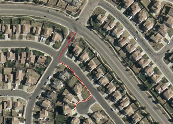
Here's a google maps satellite view of the neighborhood, red marks the sidewalk path I've cleared and been using, now I can use a narrow swath of actual street as well.

I wish the streets were really this clear!

Sunday, February 04, 2007

Meandering through South Metro Denver

Temps in the 40s-high 50s during the ride, sunny and cloudier as one approached the foothills of the Rockies.

After some minor clearing of the exit route sidewalk, I got out of the neighborhood on wet side roads until I got the main roads which were dry. The day was gorgeous and I started riding shortly after 11am. I rode my commuting route to check out road conditions and they were fine. In fact, I'd gotten so warm under the sun while doing my pre-ride checks that I only wore a t-shirt and long sleeve henley shirt under my bike jacket along with jeans with long underwear which were all I needed. I could feel it a bit cool on the arms but it was not uncomfortable for the ride to the Denver Tech Center.

Plenty of evidence of melting snow everywhere, hopefully these wet spots on the roads will not turn to sheets of ice for the early commuters. I plan to not leave the house tomorrow for my commute to work till at least 0900; that's one of the advantages of being able to work from home.

Lots of spray from the cars ahead of me but I did not care, not only did Maria's fairing and windshield absorb most of it, it also meant that it was water and not ice ahead of me! Not only that but the spray encourages one to keep a good following distance from the cager in front of one's bike!

After I got to work, I rode the usual route home as well to ensure conditions were the same as the way in. I even practiced entering/exiting the subdivision I live in to ensure no issues with traction. Water tends to collect at the entrance and if its below freezing, trouble!

After that I took Arapahoe Rd West until it ends at Broadway Blvd which I took South till I got to C470. I mistakenly headed East on 470 thinking I'd hit Santa Fe and the way to Waterton Canyon Rd which I wanted to check out. I soon realised I should have headed West on 470.

No problem, I took I-25 South for a bit and got off on Happy Canyon Rd which lead me to CO 85 which I took heading North past Sedalia and eventually to Titan Parkway and the Waterton Canyon area. Roads at this point were much more covered with gravel/sand which I did not like but it was navigable and of course you really had to pay close attention! : )

The temps must have dropped a good 7 to 9 degrees as I neared the foothills so I stopped to put the liner back into my riding jacket and don the overpants as well. I did not feel the cold after that except for a bit at the back of the neck but I did not bother to stop again to put on the balaclava.

I left the Chatfield Reservoir area and went North and took a left onto Deer Creek Canyon road to have a look see. More gravel! I cut out as soon as I could and headed back to C470. I took this pic of Maria near a Marriott Suites hotel:

Looking South towards Deer Creek Canyon Road
Once I got back on C470 I went back to I-25, this time heading North till I got to Arapahoe which I took East and back home for some gas. I then cruised to Eaglecrest High School's faculty parking lot where I got the following shots of construction equipment and housing situated in the snowy plains next to the school.
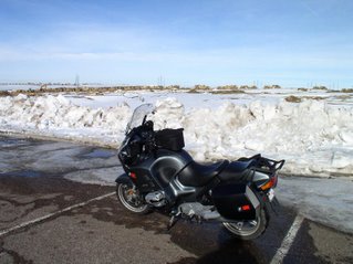
From the parking lot of Eaglecrest High School
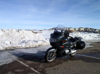
A total of 105 miles worth of meandering, got home at 3PM so about 4 hrs of saddle time with a short break on Happy Canyon Rd for a snack. It was a great ride, the temps ensured the puddles and wet spots I saw were just water and not black ice, the more worrisome stuff at times was the sand/gravel on the roads.