Starting out in mid-afternoon, John S. aka Spat and I motored out of the Archview Campground and headed towards Gemini Bridges Road. The rest of the group had gone out to Whitewash Sand Dunes to go play there.
The objective was to check out Gemini Bridges, a pair of arches situated right next to each other, and similar in shape and appearance, hence the name given to them.
We took Highway 313 west and turned onto Gemini Bridges Road right after Mineral Bottom Road. The views of the La Sal mountains were spectacular that day, the road wasn't too bad and we made good time to the parking lot for the Gemini Bridges.

The La Sal Mountains

Merrimac and Monitor

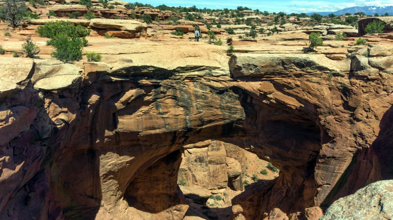
One of the Gemini Bridges, that's Spat on top of it

Best angle I could get on the second Gemini bridge
Once we got back on the rigs, it was some more riding with lots of rock strewn dirt terrain and stretches of slick rock to contend with. Still, I would come to miss this rough terrain further on.
We came to a valley of sorts, ringed by huge rock formations carved out by water millenia ago. The road was very sandy and loose, making for some interesting riding; and yet, the worse was yet to come.

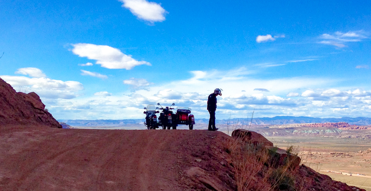
We finally cleared the valley of the stone formations and came up on the shelf road that is the final portion of eastbound Gemini Bridges Road. The views from up top were gorgeous:


That road way down there is US 191, heading into Moab


Looking down on US 191 towards the North

The shelf road sloped steadily downwards
Looking down from the top of the shelf road
photo courtesy of Spat

Spat took these two shots of me negotiating a particularly
steep section of dirt and rock, good times.

We both made it safely down to the valley below, taking it slow and steady as dirt bike riding fools sped past us.
We got onto US 191 and went back to the campground, thinking that it was so fortunate for us to have started the Gemini Roads from UT Hwy 313, and not from it's endpoint on US 191!
Day 6: Canyonlands NP's Upheaval Dome, views of Shafer Trail and Riding Long Canyon Road.
Another late start ride, with only six rigs being around to join up for it. We were headed towards Upheaval Dome within the Canyonlands NP. A bit over 27 miles later along UT Hwy 313, we were parking in the dome's parking lot area and hiked in to take a look.
Given all the climbing involved to get to the first overlook, I found it a bit underwhelming.

Upheaval Dome, from the first overlook.

Interesting looking tree at the first overlook.
We skipped the second overlook and slowly hiked our way back down to the parking lot to rejoin the members of the group who had elected to just rest by the rigs.

Mr. C.O.B and his faithful sidekick: Newt
photo courtesy Spat
Once we got going, we stopped a small pulloff site to view part of the "Islands in the Sky" stone formations.

Left to right: Chris, Spat, Joe, Debra, Dan and Yuen
Next, Spat took the lead and took us to the bigger of two Shafer Trail overlook sites. It gave us a great view of the Shafer Trail and the valley it crosses on its way to either the White Rim Road or Potash Road depending on which turn you take.

Shafer Trail


photo courtesy Spat
We rode over to Dead Horse Point State Park and got onto the trail that leads to Long Canyon Road just before the fee station for the State Park. It's not long before one is committed to a steeply sloping road which leads one to the dreaded "Narrows".

Lined up before "the Narrows"
photo courtesy Spat

A screen capture of the video shot by Mr COB
Once you get past these two obstacles, the rest of the way is smooth in comparison though with the occasional rough spots forcing you to slow down a bit.


Rest break along Long Canyon Road

The video covers the riding along parts of Long Canyon, hopefully you'll get an idea of the beautiful scenery available to you once you decide to brave "the narrows" and Pucker Pass.
We made it all the way to the end of the road where it junctions with UT 279 which we took northbound towards its junction with US 191. Half the group went into Moab and two rigs went back to the campground.
This was my last ride for this Moab gathering, I go home tomorrow, weather permitting of course.
15 comments:
You guys certainly don't go easy on your rigs, Dom. The video seems to be a Ural commercial. What an otherworldly and beautiful scenery. I'd like to go there again some time.
Trust me SonjaM, I considered turning back....but the steepness of the trail precluded that. The scenery in Long Canyon is indeed quite beautiful.
Wow, I just watched Dom Chang's video on his blog. I can't believe that's the same road we took down 10-2014
The section above Pucker Pass was NOTHING like that when we did it. And Pucker Pass itself was a lot smoother.
I can't believe how much Long Canyon has deteriorated. I would have turned back. I don't baby our Ural, but IMO that is too much.
Unknown, Sasha, it was definitely in bad shape in The Narrows and through Pucker Pass (though the pass was cake compared to the narrows). I'm thinking perhaps you lucked out and rode this road after it had been worked on?
I don't think the road was worked on when we did it, there were no signs of grading....it was just a lot smoother
Wow, such a beautiful area of the country.
I enjoyed the video too. The Narrows, should be called "Hell no I'm walking, pick me up after." Great job traversing it.
Sasha, then that's some serious erosion that occured!
Trobairitz, thanks and I am pretty sure that's along the lines of what Yuen said to her husband Dan before he took his rig through that obstacle! :)
Spectacular scenery Dom. I always imagined backpacking through that area. Long before I started riding. I suspect a dirtbike could tear along in that environment.
The Shafer Trail -- one of those switchbacks looks as if it is right at the edge of a cliff. Is that the case? Makes me woozy thinking about it...
Thanks Steve and yes, Shafer trail is basically carved out of a cliffside.....pretty cool ride.
Spectacular scenery! I would love to ride those roads.
AZ AD, yep, lots of great eye-catching rock formations, canyons and cliff edges....
must be terrible having to ride through countryside like that and looking at nothing interesting
wish i was staring at nothing like that
dpknightdunc, truly a terrible task....a task I am willing to undertake to spare all of you.
Beautiful scenery. Totally worth it. Dom, you took a great line through the Narrows, but it looked rough!
Thanks BeemerGirl, I did end up with a bent mount for the left turn signal, was surprised it did shatter it!
Post a Comment