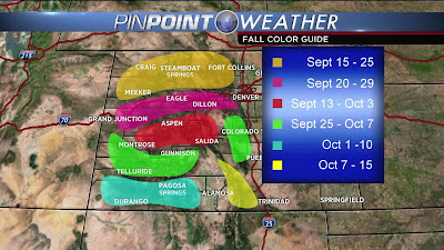
The main destination was the Switzerland Trail in the hopes it had some Fall Colors.
I crossed the metro area using the I-25 to US35 slabs to get to Boulder or the PRB in good time. I transited through the PRB and turned west using Left Hand Canyon Road. Not much color to report on this nice and twisty canyon road until you get higher up in altitude and closer to the Peak to Peak Highway aka CO Hwy 72.
On Left Hand Canyon Road, approaching CO 72 aka the Peak to Peak Highway
Once Scarlett and I reached the Peak to Peak Highway, we turned South on it to keep some distance from the cagers who were most assuredly swarming over Estes Park about 30 miles north.
I turned off on County Road 93, heading towards the Boy Scout Camp to look for Fall Colors. I found them too, a nice bunch of it at the private lake that is Beaver Reservoir.
Fall Colors next to the Beaver Reservoir
ScooterBob gets to witness Colorado Gold
That triangular peak is called Sawtooth Peak for obvious reasons.
It's one of the mountain peaks visible also from the Rocky Mountain National Park.
Back on CO 72, we headed a little further south, this time turning west into the Brainard Lake Recreation Area. It's a fee area and it cost me $10 to get in. It's more of a hiking destination however, I'll have to go back some day if I ever do pick up hiking.
A vista of the nearby peaks as one heads into the area
Pawnee Peak on the left and Mount Audubon on the right
ScooterBob near Brainard Lake
Exiting the recreation area, we headed south once again and this time stopped at a favorite spot for pictures. Unfortunately, the colors in the vicinity were so brilliant that the place was swarming with leaf-peepers, getting in the way of many picture angles. I got only one:
Heading away hurriedly from the milling cagers and leaf-peepers, we rode a short way further south and I posed Scarlett near the edge of a pullout area.
Along the Peak to Peak Highway south of Ward, CO
Shortly after the above shots, I found the turn off for Gold Hill Road. This dirt road was pretty much lacking in terms of Fall Colors however. I did find the turnoff for the Switzerland Trail and spent the next hour or so bumping along slowly on this rocky trail.
Progress was slow as I didn't want to loose the fillings in my teeth or parts off the rig as we descended down into the valley. Again, no real fall colors or very scenic shots so no pictures taken. Finally, reached a junction with County Road 118 which became Four Mile Canyon Road.
Very nice and twisty, this canyon road, but again no Fall Colors or much in the way of scenery. A few miles down this road, we came upon this imposing rock/brick structure that used to be a mill for the Wallstreet Gold Mine Complex back in 1902:
Not much remains of the other buildings but there was the Assay Museum just a bit further on from the mill structure. I didn't stop, but if you're so inclined, the museum is waiting for you.
Update: 22NOV16: While searching for something else, found this picture of what the mill looked like back in the day:
source: X-61546
Four Mile Canyon dumped us onto CO119 which we took towards Boulder. We took CO93 from Boulder to Baseline Road and from there swiftly left the PRB and transited north of the Metro Denver area to I-25.
I-25 would take us to 104th Street east, to Tower Road at the town of Reunion. From there it was just boring usual roads back to the home neighborhoods.
Scarlett ran pretty well though once in a while she'd run a little rough in first gear. I think the air filter might need replacing. I'll find out this coming week as Scarlett went over 40K Km during this ride and it's time for services!


