Wednesday, September 02
It started off as a ride north of Buffalo on Interstate 90, to see what lay in that direction.
Unsurprisingly, not much but lightly traffic'ed superslab, and lots of ranches with cows and horses along both sides of the road.
I thought to go all the way to Bighorn, thinking perhaps there's be some revelation there as to the naming of the Bighorn National Forest perhaps. Alas, no.
The town, such as it was, did have a close proximity to some interesting looking portions of the Bighorn Mountain Range. I skipped on visiting the Britton Museum, just didn't have it in me today I guess.
Instead, looking for a spot to pose Fiona to get the aforementioned mountains in the background, I spotted two horses who had run up to the fence upon sighting Fiona! I figure they are used to some vehicles stopping to give them snacks perhaps?
Regardless, I took the opportunity to not only capture the mountains but the horses.
Having no sugar cubes on me, I couldn't lead the horses away
from the fence post and utility sigh....
I tanked up at the gas station near the junction with Hwy 87 and using it, made my way back to the I-90 Slab returning towards Buffalo.
While Bighorn, the town, proved "meh"; the stop I then made to check out the remains of Fort Phil Kearny along the way to Buffalo proved a good decision.
It's not far from the highway, and while not much remains (not surprising since it was all made from wood harvested in the area), there was enough reproduction of structures to give one a pretty good feel for what the place was like in terms of space anyways.
A reproduction of the front of the fort is available to give you an idea of the protection they provided:
As is usual, there's informational plaques located about, giving you tidbits of information. I didn't walk to all of them, here's some that I found interesting:
A drawing/painting, heavily sun-damaged, depicting the buildings
within the walls of the fort.
Then as now, one isn't going to get rich as an Enlisted Man
The fort's short lifespan I think was attributed to the establishment
of a railroad line that obviated the benefits of using the Bozeman
Trail, which this fort was tasked to protect travelers on.
Note the circled object above, the sight tube below
aids in locating it for today's viewing
Some of the signs had a pole next to them, with a sighting tube
to aid in locating the object/location being described on the plaque.
Great, it was Treaty-guaranteed Indian land, and yet such
things were ignored, resulting in conflict.
That's I-90 using the same route the Bozeman Trail did.
They've installed small mounted figures on top of the ridge,
to give you an idea of scale and perhaps the imagery of riders
watching over the fort. Or perhaps, Indians watching the fort?
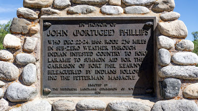
A few minutes away, I rode Fiona to the monument near where the Fetterman Battle occurred.
Only 3 NCOs for 76 junior enlisted? The times were different in
the Army back then. Command and control must have been "difficult"
in combat.
It was getting quite warm at this location so I went back to Buffalo to tank up the spare gas tanks and headed on back to the campsite. You could feel the temperature drop as you gained altitude. The campsite location is a bit over 3300 feet in altitude higher than Buffalo at almost 10,000 feet!
Note: I found it interesting, how many forts and installations used the name Kearny. Apparently a common name of Irish origins.


No comments:
Post a Comment