Saturday, April 30, 2022

Home for a bit....some stats and notes

Let's see, I spent 89 days on the road....returning home on day 90.

Boondocked in 3 states: New Mexico, Arizona and Utah.  Didn't camp anywhere where fees were required.

Drove the VRRV for 2586 miles total.
image source: link

Best location: Valley of the Gods, Utah (assuming you get the primo spot I used)

Worst location (in terms of crowds, and noisy ass wipe types): Moab, Utah.

Expenses pie chart below, doesn't include costs involved with getting new tire, new tubes and repair items for Scarlett as not exactly camping related.

Two weeks long stays in one location key to keeping fuel costs down, but of course groceries costs go up.

26 gallons in Fresh Water Tank lasts about two weeks with normal usage, for one person.  This assumes separate 5 gallons for toilet flushing duty.

Propane usage, assuming no extended cold weather, about 1/4 tank per week.  Mostly used for fridge and cooking.

100 Watt Solar Panel enough to recharge battery given an average drain of 10 Amp Hours overnight.  Angling the panel outside of peak solar hours remains key.  Adding second panel would eliminate the need for angling of panel but then you lose flexibility in terms of panel placement when under trees and such.

Cost of camping was $27.49/day out
of which $8.69 for food

The surge in gas prices due to the Russian invasion of Ukraine didn't help things of course.  I still find it ironic that Utah gas prices are an average of 50 cents higher than in the Metro Denver cesspool area.  It's a sad state of affairs that I was happy to find the cheap gas for $4.15/gallon!

Now, time to prep for the next camping trip.....

Wednesday, April 27, 2022

Uraling to Spring Bottom Canyon and a relaxing last day of camping

 Tuesday, April 26

A warm day today, it would get into the 70s but with cloudy skies muting the effect of the sun's rays.  Still, very nice.

I rode Scarlett, my 2014 Ural Patrol Sidecar Rig, to Utah Hwy 313 which takes one to both Deadhorse Point State Park and the Canyonlands N.P.  I would turn off before both though, at the Lone Mesa Campground.

From that junction, it's about ten miles to the start of Spring Bottom Canyon Road.  There's a nice rock shelf which we've used in the past, during Ural Sidecar rallies, to pose our rigs on the edge of the precipice.

I managed to leave camp without the Sony Camera's memory card so all the pics are from my Pixel 4a Google Phone.

Today, it was only Scarlett:


From a bit further on, one can look at the road crossing the bottom of Spring Bottom Canyon.  Scarlett and I would be on that road shortly.


It's a narrow shelf road, carved out of the canyon wall, that leads one to the bottom.  Not too rough, some bouncy bits but otherwise not bad if you go slow and easy.

I got to the bottom with no issues, had a rest at a roped off area (campsite?, no signs) near the Green River,  then headed back on up to the top:


The rock columns are the same as the ones
in picture 4

Looking back towards the river


and back up on top....

I thought the Pixel 4a's camera did pretty good.  I made my way back to the junction with Utah Highway 313 and returned to camp shortly after.  It's about 35 km from the junction of Dalton Wells Road and Spring Bottom Canyon.

Though the canyon area became overcast and cloudy, the camping area was sunlit and warm.  I checked Scarlett's Final Drive's fluid level and found it just shy of the top mark on the dipstick.  For whatever reason, there's been no further leaking of gear oil from the front seal.  Hmmmm, not complaining mind you.  

Wednesday, April 27

Spent most of the warm day relaxing mostly, did some temporary repair work on Scarlett's right side pusher shock absorber mounts.  The rubber bushing has disintegrated, causing the shock to be slightly misaligned.  I think I have some bushings at home, so that's added to the post-camping task list!

Later in the afternoon, I took Scarlett for what is probably going to be her last off road ride for quite a while.  We went up Gemini Bridges Road, entering from US 191.  Rode up to the "viewpoint" I've used before.


Got back to camp with no issues and got things ready for a fast departure for home tomorrow morning.  Both motorcycles are loaded up along with most of the outside gear.  Just have to pack things up inside in the morning and its back to Colorado I go.

Monday, April 25, 2022

A Restive Sunday, Riding the Shafer Trail and the Sony HX-80 Camera is Toast.

 Sunday, April 24

Woke to find someone had parked their popup camper near the tent.  Fortunately, he decided to leave shortly after I had breakfast.  He was a loud music player too, good riddance.

I went with Scarlett down to Moab for a grocery store run, came back to find may other campers had left the Dalton Wells area as well.  Again, good riddance.

By late afternoon, it was much less crowded and much quieter for the most part, and my soul felt more at peace than during yesterday's congestion and weekender crowding.


You'll noticed I repositioned things to better occupy the spot that used to house two RVs and a tent.  Just trying to keep some isolation until I leave here sometime this week.

Note to self: The Moab area is just too popular and crowded.

Monday, April 25

A "mo better" day in terms of crowding in Dalton Wells.  I've only one camper van within easy line of sight now.  Good enough.


Rode into town to get something from NAPA and then headed up on Potash Road towards the Shafer Trail.  I usually do it from the top down, using Canyonland's N.P. as the starting point.  Today, I rode it from the bottom up.  I think it's better in terms of spotting good picture backgrounds.


I liked the mushroom capped rock pillars


You can see the upper portion of Shafer Trail

The road has been improved greatly, its not as rough as I remembered it on a Ural but then again, that was years ago.

Once up on top, it was 31 miles back to Moab, about 33 back to the campsite.  I got back around 2:30 PM or so, oiled the chain on Yagi and rested the rest of the afternoon.

One short ride though, the La Sal Mountains were so clear today, I had to get another picture:

The last picture by the Sony HX-80

The Sony HX-80 camera, with its pretty great 30X zoom capability is toast.  It had been giving me trouble with its lens deploying the last few weeks.  So I made a claim to Sony since I'd bought the extended protection plan.  Turns out, Sony said it would cost more to fix it than to pay me the cost of the unit!  Sad.

So, they refunded me the money I paid for the camera.  The camera still worked, kind of, for a bit but today nothing I tried could get the lens to extend properly and seat.  Oh well.  So, bottom line, the Sony HX-80 isn't robust enough for motorcycling usage, at least, my type of motorcycling usage!

Saturday, April 23, 2022

Riding to Onion Creek Road proves a "wet" experience...and once again camping alone

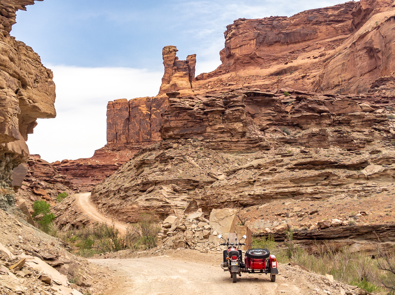
 Today dawned overcast and with a good chance for rain, though forecasted accumulations were said to be around 0.06".  So,  I felt pretty confident suggesting a ride to Onion Creek Road located about 20 miles N/NE of Moab.

We got there with no issues and under overcast but not really threatening-looking skies.  The road conditions were fine on this dirt road, and we were enjoying crossing over the Onion Creek where it meandered across the road.

I lost count of the water crossings after a bit, hadn't seen so many the last time I was here during a Ural Rally.

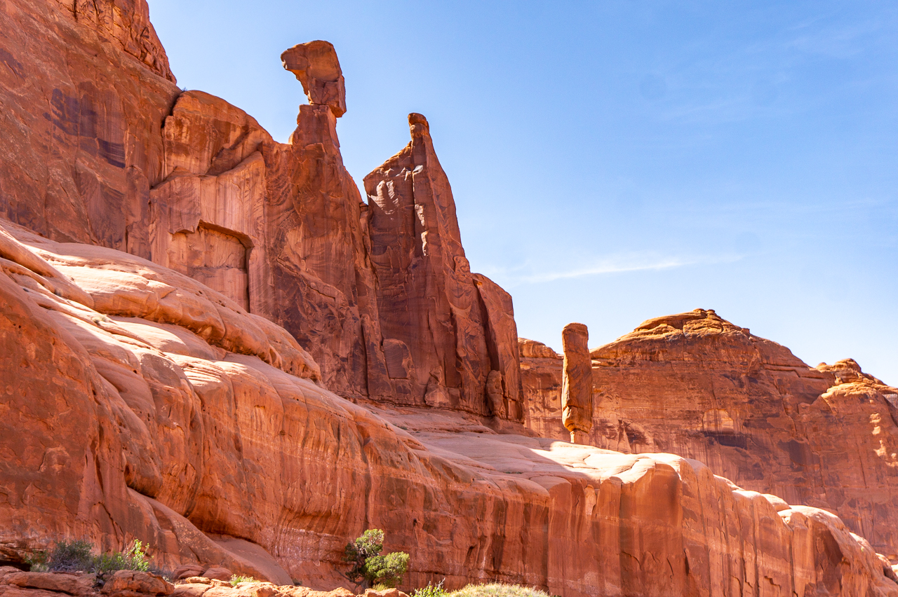
Soon enough we reached the really scenic rock formations/walls of the canyon formed by Onion Creek over the millennia.


At this point in time, we'd been feeling an occasional drop or two of rain, commensurate with the forecasted 0.06" of accumulation.  So no worries, we kept on going.

About two-three miles later, the rain was becoming pretty steady so I decided to turn us around and start heading back to US Hwy 128 and pavement!  

I should have turned around sooner, the rain got pretty steady by the time we returned to the pavement and we got a pretty good and windy soaking before we got to J & J's Mercatile Store within the nearby Sorrell River Ranch Resort.

Unfortunately, the store wasn't open.  It wouldn't be till May, but there was a lady inside doing inventory and she let us stand at the open doorway out of the wind.

We hung out there, trying to stay somewhat warm and at least to me, enjoying the feeling of being able to feel with my finger and toes, wet as they were.

Perhaps an hour later, the rain let up and the skies were starting to look clearer.


Before, while it rained hard, you could only the a vague outline of the above rock formations near the ranch!  Sorry, no pics, was too busy shivering in my wet riding gear.

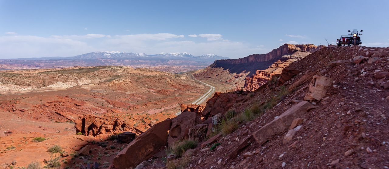
Finally, we rode out and chased the open patch of sky to the south, finally enjoying some sun as we neared Moab.  Sadly, this sun exposure didn't last as we saw forbidding clouds and rainfall in our way.

The last four miles or so to the campsite, in a word, sucked.  Strong, very strong winds, hard rain and I think some hail for a few seconds, made it quite the perilous riding conditions.

Steve had peeled off from us back at the ranch to go get gas, so it was just Bob and myself that "enjoyed" the lousy weather until we finally reached the shelter of our respective RVs!

Steve later arrived safely and we all sheltered in our respective habitations for the rest of the afternoon.

It would even hail on us, pea sized, amidst lightning and thunder for about 10 minutes around 6:00 PM.

Saturday, April 23

Both Steve L. and Bob W. packed up and left this morning.  Steve is continuing to do some riding and Bob is headed home.


I spent the rest of the windy and cool but sunny day dealing with issues resulting from replacing the brake pads on the pusher wheel on Scarlett.

Tried for quite a while, but couldn't get the piston pushed back into the caliper far enough to allow the new pads to fit.  Finally ended up removing the bleeder valve on the caliper and that did the trick.

Of course, that also allowed a bunch of air into the brake circuit.  Tried to bleed it unsuccessfully for quite a long time, even invoked RichardM's assistance, disturbing his dinner unfortunately.

In the end, I realized you have to rotate the caliper 90 degrees to the rear, so that the bleeder valve is pointed up...then, and only then, can you get all the air bubbles out of the circuit!  Now I have brakes again all around.

Dumb design on that brake caliper!  

Thursday, April 21, 2022

Arches N.P. with Bob and Steve with a Hike to Delicate Arch

 Wednesday, April 20

I rode with Bob and Steve and we motored our way into the Arches National Park to allow them to check out the sights; it was their first time at this park you see.

After first checking out Balanced Rock, we turned our motorcycles towards the parking lot/trailhead for Delicate Arch.  The hike up to the arch is 1.5 miles and it wasn't too bad since the weather was nice and our pace was OK.  The crowds at the arch weren't as bad as I had feared.  This was, by the way, my first time at the Delicate Arch.

Bob and Steve lined up in the reasonably short line to pose under the Delicate Arch.  Soon, it was their turn.

image courtesy of Steve L.

Steve L.

Bob and Steve

Bob W.

Bob and Steve with the side rock formations near
the Delicate Arch


A view of how steep things are at the 
Delicate Arch, as seen through a "window"
in the rock formations before one arrives at the arch.


another view of the sandstone formations seen
from the path to the Delicate Arch

yours truly
image courtesy of Steve L.

After a rest break in some shade, we made our way back to the motorcycles with no issues and proceeded on to other rock formations within the national park:

Skyline Arch


A tired Bob at Courthouse Tower

Park Avenue


We returned to the campsite to find the neighboring spot occupied by three RVs and some assholes playing music way too loud.  After dinner, I decided to go scouting for another site; the guys understood and were quite willing to get away from the noisy assholes next door.

I found a site further into the Dalton Wells area, and we all did a hasty displacement to it.  Ah, quiet once again.  We lit a nice fire and toasted the regained silence with some Makers 46 Bourbon.

In the morning, a neighboring site was emptied and since it was "mo better", we moved to it once again.  This time, it was only about 200-300 feet across the main Dalton Wells trail.   The prevailing winds will now keep the road dust stirred up by passing UTV/ATV traffic away from us, so that's good as well.

There's also a better internet signal here as well.


Thursday, April 21

After a leisurely morning of moving to the new site and some chores, we all drove into Moab in Bob's truck to check out the town.

After a lunch at one of the tourist traps, we visited the Moab Museum.  It's a tiny facility but there were some interesting nuggets of info interspersed with the usual old western living items.  

In case you wondered where the name of the town came from, and no, it's not the initials for Mormons On A Break; or Mother Of All Bombs.


Charlie Steen's bronzed boots, he was known as
the Uranium King in the town's heyday as Uranium
Capital of the world.

There were several small kiosks displaying vintage photographs of town living/personalities and such.  One that caught my eye was the sight of "Uranium Jewelry" being sold.  If those people only knew....


After some wandering around the tourist trap shops along the main drag, we finally left town and returned to camp.  Steve L. went for a ride by himself, while I helped Bob W. deal with a leaky connection on his camper's hot water tank.  This involved another trip into town for the parts involved, but now that is fixed.

So, Thursday was a pretty easy day, and with the exception of Steve, no riding by either Bob or myself.