Not a bad facility, somewhat level sites, carved out of a thickly forested section of land right by Colter Bay. Full hookups. Wifi only works in certain spots such as the laundry room, restaurant, and the guest lodge. 4G coverage is crap, even with the WeBoost. Had three bars 4G LTE but no internet, my guess is the local tower is saturated. Oh well.
There's good 4G coverage on the roads within the park, in spots.
We arrived under heavily overcast skies and cool temperatures. Cagers were infesting all the roads of course so that was a detractor. Still, it's weekend traffic in a popular National Park, am sure it's much worse at nearby Yellowstone NP.
The light was terrible and conditions hazy for pictures Friday afternoon:

Near the boat ramp at the Colter Bay Marina

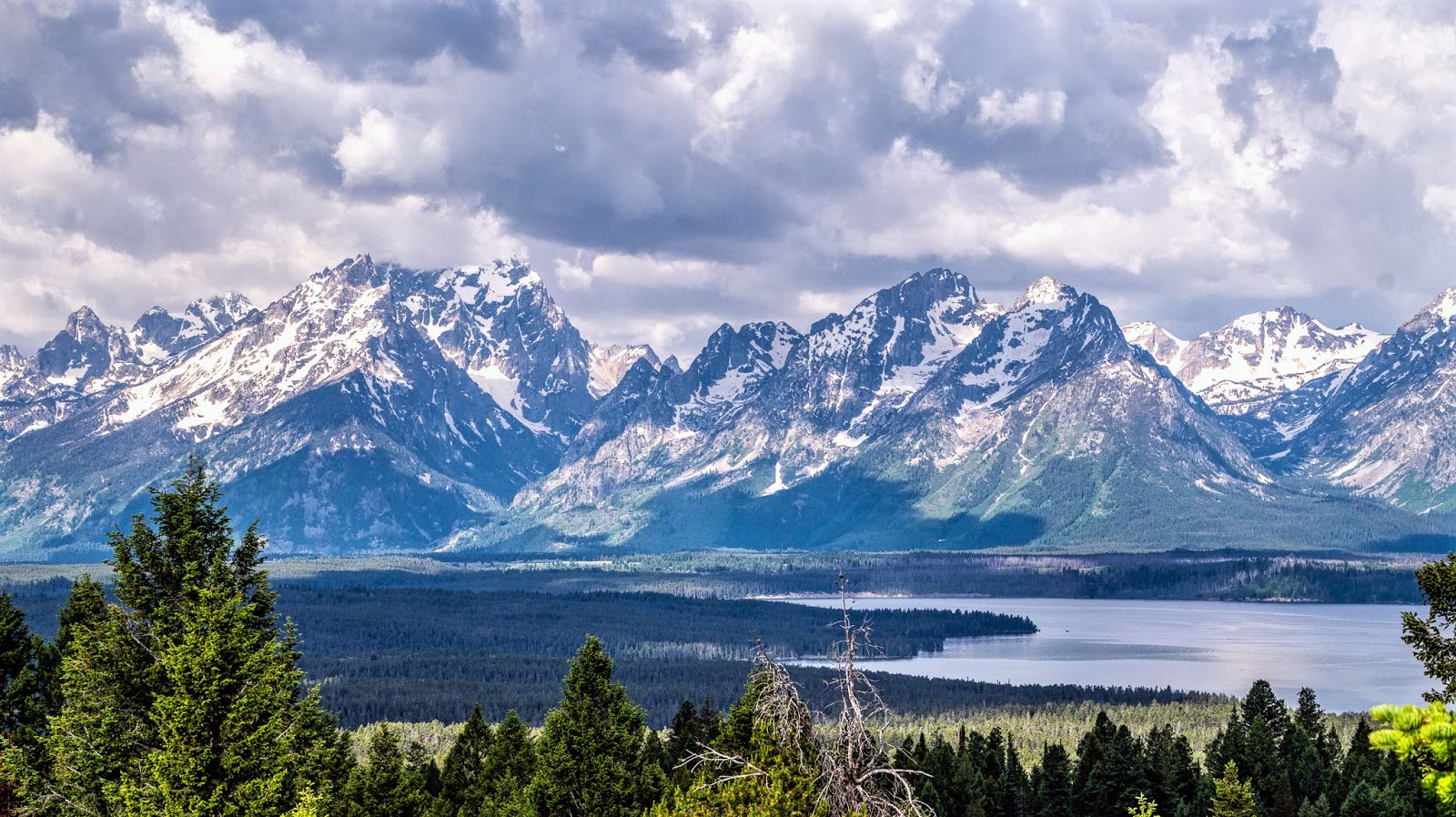
Views from near Jackson Lake Lodge, I think.

Large peak on left is Grand Teton, the large and highest
one on the right is Mt Moran


Pano shot on the way to Jenny Lake area
Martha and I did the whole loop, checking out possibly shooting locations for the next day. Back at camp, we relaxed a bit after dinner and then headed out to the nearby "beach" next to the campground hoping for a Sunset shot.

This time of year, the sun sets north of this angle on the
nearby mountains.
The next day, I didn't get up till around 7AM. Martha was off on a walk to achieve her daily 10K steps with the Fitbit; so I went back to the shoreline to see what I could see:
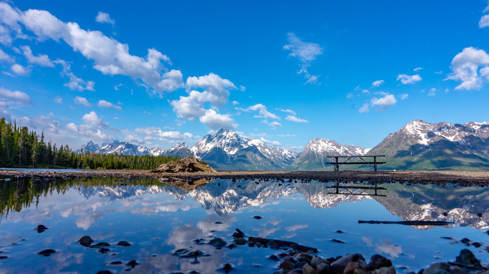
The Grand Teton Range and its reflection on a puddle

Getting back to the RV, I geared up and road Scarlett out to the point near Jenny Lake that Martha and I had selected. Martha was still on her walk and arranging a boat ride for herself in the afternoon.

Pano of same spot from yesterday afternoon to highlight
the differences in lightining.

Part of Grand Teton peak

To the north of Grand Teton, Storm Point and Mount St. John

Retracing my route, I detoured the six miles or so to ride up to the summit of Signal Mountain, hoping for nice views.
At the very summit, there was a good view of the valley below but as you can see, not much of the mountain range to the west.


Descending just a little bit, there's the Jackson Lake Overlook which after a short walk, offers nicer views of the mountain range:


The highest peak is Mt. Moran

The road up to the summit of Signal Mountain is slightly twisty with a few blind curves so you have to watch out for unwary and clueless cagers stradding both sides of the narrow two lane road.
Back on Teton Park Road, I stopped one more time for a last shot of Grand Teton hoping for a water reflection but no joy there.

Rode on back to the campground, only stalled once for a traffic jam involving a large delivery truck and a car. Not sure what the hell caused the jam but it's part and parcel of the overcrowded conditions our more popular National Parks are enduring.
We'd originally planned on staying Sunday night as well but I think we'll leave early Sunday morning and get a good start (plus hopefully avoid the heavy traffic congestion for which Yellowstone is known for) to find a BLM boondocking spot somewhere halfway to Helena, Montana.
7 comments:
Not quite boondocking but we really like Lewis and Clark Caverns State Park in MT. Pretty cheap and the cavern tour was good. I had Verizon but no AT&T.
Thanks for all the lovely pictures. The park is as beautiful as I remember.
Marvellous, Dom, especially the reflection in the water. Brilliant panos as well.
Beautiful images! I love the Tetons. We were bike touring when we visited, spend an extra day there, but we were mostly on foot. Looks like you found some great roads and views that I didn't get to see.
We bypassed the caverns park, RichardM....ended up in Helena.
Andy and Laura, you're welcome
SonjaM, thanks, the water was from a medium sized puddle! :)
Thanks Kari, the park's road system is not very diverse but sure covers a lot of area so not surprised that you didn't want to walk all of it. After a while though, it's basically the same set of mountains.... :)
Beautiful images Dom - what a great experience!
Thanks MotoVentures....
Post a Comment