I packed up the rig and was riding into Durango just past 8AM and by good luck I happened to catch the Silverton - Durango Train as it was also leaving town headed north!
I motored ahead of it and positioned myself near one of many railroad crossings along US550 and got this video:
After the train passed, I got back on Scarlett and actually passed the train as we moved at URAL speed north on US550. This time, I positioned myself to catch the train at another railroad crossing:
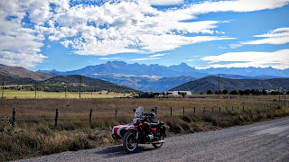
Train chasing done with, Scarlett and I headed north and captured a few pictures along the way.
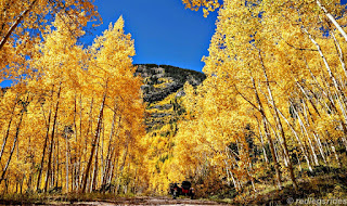
Shortly after the small town of Hermosa, I took the exit for the Lime Creek Trail also known as Forest Road 591. It turned out to be ten miles of hilly/rocky/gravelly forest road with technical spots and terrain to keep one quite entertained and somewhat fearful at times. The scenery along the way was as beautiful in terms of Fall Colors as the stuff one saw on the highway.
Emerging from FR591 back onto Hwy 550 and I cruised north a short distance before spotting the sign for "Ophir Pass". I went past, but shortly afterwards made a u-turn and decided "what the hell" and go for it. After all, two other Uralisti couples had made it up to the summit of the pass, surely Scarlett and I could do it as well.
The road from the eastern end of Ophir Pass road begins pretty easily though with its steep parts. It got worse as I gained altitude but still it wasn't as bad as the rocky sections on FR591. Still, once I got near the summit, there came a set of switchbacks with steep inclines which overheated my clutch.
let the clutch cool down a bit.
made it up to the spot below. You can see how steep things
were for Scarlett and I in the pic above.
clutch to cool down. I amused myself by building the stack
of rocks pictured above.
The 20 minute wait did the trick, and I gunned Scarlett's engine and we shot up to the top of the pass. In less than a mile, we were at the summit sign.
It must have been a good 15 minutes of taking pictures up on top before I decided to start headed back down the way we'd come up. I didn't go down towards the west side of the pass road as I would have ended up somewhere south of Telluride and stuck with riding the long way round on the San Juan Skyway back to Durango.
Here's some of the sights as Scarlett and I descended back down towards US 550.
Back on US550, I headed north with the eventual thought to overnight in Gunnison, CO. Along the way, Scarlett and I got a few more Fall Color shots:
Passing once more through Ouray and tanking up at the gas station to the north of town; I made my way to Ridgway thinking at the time to go to where US50 junctions with US550. Instead I zoomed past the sign for Owl Creek Pass. Once again, I made a quick U-Turn and saw this:
What a gorgeous set of mountains right? It made the decision for me to ride Owl Creek Pass road to get to US50 instead of boringly paved highway.
The centerpiece of this mountain range is called Courthouse Mountain
I would end up really close to the leftmost rock formation that looks
like a watch tower.
wash-boarded sections that threaten to shake things loose
on Scarlett and me.
Getting closer, a view of the peaks from "Vista Point"
reached the summit of Owl Creek Pass
The requisite picture of the pass sign. I let Scarlett cool
down here for a good 20 minutes or so as she was
smelling "hot"
Nearby the summit sign, I found the below small stream coursing slowly by. I cooled off a bit with some of the cool water and then spent a few minutes playing with the camera's shutter priority mode to "blur" the water stream. What do you think of the result?
Everyone cooled off, we motored on down Owl Creek Pass road towards the valley below, here's some sights:
There were perhaps ten people, with large lenses attached to
expensive looking camera gear; all looking at the shot above, waiting
for sunset I think. I just shot it and kept riding.
It would be at least ten more miles of gravel road before I finally got to US50 only to find myself over fifteen miles west of the campground (Elk Creek) where I had decided to stay. I passed by the one suggested by fellow Uralista Jay B as there was no cell signal there whereas I knew there was at the Elk Creek Campground by the Blue Mesa reservoir.
The sun lower and lower as I motored eastward on US50, I finally got to the campground as the last rays of the setting sun were painting the sky:
Picked out a site (there were plenty of spots), got registered and once back at the site I started setting up camp. The super moon/blood moon combination started up right then and I spent a hurried bit of time setting up camp, trying to get shots of the moon as the eclipse happened, cook dinner and also check in with Martha.
At the beginning of the eclipse, after a while I gave up.
Dinner was freeze-dried Chili Mac as darkness enveloped the campground and temperatures dropped.
I was a tired puppy today, lots of riding on rough trails and that always jostles things around enough that one is happy to lie down for the night.


17 comments:
What a great trip and photos. Though nothing beats a running steam locomotive!
Thanks RichardM, hopefully Jack Riepe will like it.
Spectacular, Dom, and for so many reasons:
It's funny--your first photo of Scarlett after your turn-around on Ophir... I took a photo of my GS in that very spot on my first trip to the San Juans in early September 2012. As I'd ridden in from the west, from Norwood and Gateway and from Moab on some a great dirt routes over the north end of the La Sals (ultimately from Salt Lake), Ophir was my first pass in those amazing mountains, the threshold to a transformative adventure. Sure, Utah and Nevada, where I've done most of my riding, have some incredible terrain, but, Dom, I am in love with those mountains and their mining history. Of course, I saw some gorgeous leaves over there in 2012, but it looks to me like you could not have chosen better days. You've seen (and photographed) perfect fall leaves--and I mean perfect.
At the bottom edge of your last photo of Scarlett on Ophir Pass, before your return to 550, is something I intend to investigate on my next trip: There's an old mine there, just above the Middle fork of Mineral Creek, with discharge that is white, foamy looking. In the four times I've crossed Ophir, that mine discharge has always had that appearance, which is unique for every discharging mine I've seen. I intend to hike down to check it out, to know why it appears so white and foamy. Weird stuff, man.
Thanks for these blog posts--I've really enjoyed them. Of course, they've only made me want to journey back to that neck of the woods, to once again ride the San Jauns and their passes, but there are worse temptations.
With tears in my eyes, Thank you from the bottom of my heart for your Awesome photos and commentary. They brought back so many wonderful and a few scary moments of the Western Slope.
Ry Austin, glad you liked the shots and they reminded you of what was apparently a great set of riding days. I too love the Moab area but always prefer the Colorado Mountains in the end, though the Alps come a really close second! That "white foamy thing", I remember thinking "that's weird" but not curious enough to hike up there to see for myself. :)
I remember also spotting, somewhere along US550 afterwards, mine tailings that seemed white in color...strange.
Thanks for your comments! Next time you're in Colorado....
Sandy Barry Gally....very glad you liked the postings and that they brought good memories for you. Thanks for commenting.
Now that you've done this... aren't you curious about what could be done in the fall foliage of Eastern US or Canada? My absolute favourite is #4208 due to the multiple colour scheme. And the blurry picture of the water turned out well. Bei all means, try more of these.
SonjaM, it would be nice to check out the foliage in the NE part of the country someday.
The blurry water picture turned out to be pretty simple to do actually. I'll try and do more.
What a beautiful ride, pics, display of terrain and colors! Yes, the pic of the water was nicely dreamy and blurry. Really lovely...
What lovely pictures and views of the varied terrain and changing colors. Yes, the water looks nice and dreamy and blurry.
Wow! You did some serious riding and got a lot of really good photos. Not to mention having gotten out in some great weather in some great places at a great time of year. That area around Lake City and Silverton has got to have some of the best color to be found anywhere.
Thanks for your comments KenB, it was a good set of riding days and mother nature was very cooperative indeed.
Sojourner, glad you liked the pics!
What a beautiful journey and amazing pictures! The train image is stunning!
motoventures, glad you liked the pics....
Sublimes photographies
Merci
Post a Comment