The ride up was via the super slabs, which were quite clogged with westbound traffic for whatever reason. Perhaps it was my late start and this was the usual condition of traffic on I-70, who knows. I left westbound I-70 at the CO9 exit near Dillon, I was looking for a peninsula that projects onto Dillon Lake which looked like it might provide some good scenic shots. It was not to be and I had to content myself with this shot of the town of Frisco:

Overlooking Frisco, CO
Next was some more I-70 riding westbound, this time to take the CO91 exit towards Leadville, CO. The weather, which had been mostly overcast until then, become just partly cloudy and the sun's welcome presence made things a bit warmer.

One of the mountain peaks visible from CO91 on the way to Leadville, CO
Once at Leadville, I tanked up and had a snack while checking in with my loving wife. I next found County Road 4 which I knew would take me to Hagerman Pass Road. Trouble was though, there was some bike race going on and what with the bicyclists being all over the road and the event organizers "attempting" to direct traffic, I missed the turn for Hagerman Pass Road. Much time was lost dodging bicyclists and pretty much going all the way around Turquoise Lake!
Finally, I found the turn for the beginning of Hagerman Pass and thankfully was able to get away from the bicyclists in short order.

Riding on Hagerman Pass Road, the easy part, one can see
views of Turquoise Lake
There was plenty of car and bicycle traffic on Hagerman Pass Road, the road itself was packed dirt with gravel all over. Very easy road up until I reached the 4WD portions, then suddenly, I was alone! The road became steep and heavily embedded with rocks poking out of the dirt ranging in size from a large fist to ham-sized and bigger! There was nothing else but to gun the throttle, keep Valencia in first gear and launch her upwards up the narrow rock-strewn path!
Valencia did magnificently, I was jounced around severely, being reminded of the rocky conditions on the Argentine Pass Road and also Rollins Pass Road. One had to dodge and weave the large rock formations for long stretches which tested Valencia's suspension and my ability to hang onto her handlebars.
I finally stopped near where I could see the timberline finally stopping. It was time to give Valencia's clutch components a chance to cool down and for me to "gird my loins" for further upward travel. As you can see below, things got narrower and the rock content on the road didn't diminish, although now there were water filled holes to contend with as well!

Rest break on east side of Hagerman Pass.
One of my fellow Uralisti, who'd been up to the summit on his GS, had rated the eastern side of Hagerman Pass as much more "technical" than the western side. I now well believe him. Holy Crap. Still, as I neared the top, things either got a bit "easier" or maybe I was getting used to conditions. The sky overhead darkened as I reached the summit and things were a bit chilly. Still, I didn't care, for I saw the sign announcing the summit. We'd made it! If I ever ride this pass again, it's going to be in the company of other Uralisti, it's remote and the conditions were tough at times.
Mosquito Pass, which is nearby, is now officially off my "to do" list of mountain passes. Another fellow Uralista who's done it, Dana aka DirtyDR on advrider, rates it ten times worse than Hagerman Pass.

Valencia the summit of Hagerman Pass
We now started descending down the western side, and while it "seemed" easier, there was still plenty of rocky stretches to negotiate and negative camber spots to deal with while slowly weaving my way past the larger rocks and boulders.
I was more than ready for when I'd reach a low enough elevation that the road became part of an old railroad roadbed. Now the slope was never more than 3% and conditions were packed dirt at most with some gravel here and there. Easy stuff when compared to the stuff I'd just negotiated! The picture below shows where I stopped after hearing some rocks hitting the underside, I wanted to make sure there was no damage. Thankfully, there was none.

On the west end of Hagerman Pass Road, I think this is actually part of
Frying Pan Road at this point.
As I positioned myself to take the above picture, I looked down to make sure I didn't step off the edge of the road and spotted this:

Yep, an old railroad spike!
Now before you think to yourself: "Now there's a lucky souvenir".....I managed to ride off from the above spot with my parking brake engaged! I dragged the pusher wheel's brakes for several miles! By the time I noticed, there was smoke coming out of the rear hub and it had gotten hot enough that grease had melted out the side of the wheel hub! It had gotten so hot, that some of the Final Drive fluid had spit out of the venting cap! Damn.
Of course before I noticed all the above, I'd motored along Frying Pan Road, past the reservoir near Meredith, heading towards the town of Basalt, CO. Along the way I saw two deer by the side of the road, thankfully in plenty of time to slow way down before passing them. I was going much faster though, perhaps 40 mph when the bear and I saw each other. The bear had been sitting by the side of the road next to some bushes so I didn't spot it till we were both even with each other, perhaps 10 ft apart.
He looked at me, I looked at him as I kept moving and he quickly turned and ran back into the forest! Sorry, no pictures, I chose not to stop and try and get one!

I stopped here, near what remains of the town of Thomasville, the
two huge ovens/furnaces had caught my eye.
I used this time to let the rear wheel hub/final drive cool down and I added
some final drive fluid to replace that which had boiled out.

Frying Pan Road eventually turned from dirt to pavement as the sun dropped lower and lower down into the western mountains. I had kind of hoped being able to get to Aspen and the Maroon Bells Recreation area before sundown but that also was not to be.
It was dark as I exited Frying Pan Road into the town of Basalt. The police were for some reason detouring traffic around main street so I ended up on CO82 and thought I might as well head to Aspen and try to find lodging.
20 miles or so later, now quite dark, I was in Aspen and finding to my dismay that there were either no rooms anywhere that were affordable or some places didn't even bother answering the phone! Much dithering and consultation with Martha later, I was back on the road heading towards Glenwood Springs, almost 50 miles away.
I checked in the towns of Basalt and Carbondale, no room at the inn! Apparently, I'd picked the one weekend where all the hotels/motels in the area were full with folks trying to squeeze in some summer vacation time before school starts later this month! Aaarrrgghh.
Shortly before 11:00 PM though, I entered the town of Glenwood Springs and the second motel I spotted, the Cedar Lodge Motel, had one room left! It was affordable but it was small and a smoker's room. Well, like I told the night clerk, beggars can't be choosers!
I hit the rack shortly after midnight after a late meal of fast food. The smell of cigarette smoke in the room was quite overpowering at first but some time with the AC on full blast, and doors and windows opened helped a lot.
After a fitful night of sleep, I woke at 6:00 AM and hurriedly packed up my gear and hit the road back towards Aspen. I was hoping to catch some nice early morning light in the area of the Maroon Bells. The ride was in light traffic on CO82 and it was a bit chilly but not too bad.
I got to the Maroon Bells Recreation Area in good time, paid my $5 to get into this US National Forest Fee area and after a bit of wandering around got these shots.

Posing Valencia on the approach to the Western end of the Maroon Bells
Recreation Area. No, I don't know why they call them Bells, they look like
your typical mountain peaks to me.

Maroon Lake Views

I left the Maroon Bells behind me soon enough, cruised through the small mountain tourist town of Aspen once again and pointing Valencia on eastbound CO82 towards Independence Pass. The ascent went smoothly enough, I kept pulling over to allow the cagers "racing" their way to the top to get past me. Not sure why they were in such a rush.


It was a very hazy morning on Independence Pass Road


You can see how the road hugs the side of the mountains on
it's way to the summit from Aspen

A view of the western valley, Aspen is a few miles to the west

The requisite picture of the summit sign

You get some nice views of neighboring mountain peaks as you
descend down the eastern side of Independence Pass Road

Did I mention it was very hazy?
I motored down Independence Pass Road till it ends at the town of Twin Lakes. I like to take pictures of these lakes with the massive mountains that seem to come almost down to lakeside. The ongoing drought's effects on the water level were quite obvious as there were people and ducks walking about where I remembered there had been water!

See what looks like sandy flat areas? There used to be water there.

Further to the east, there's still water on this part of the Twin Lakes.
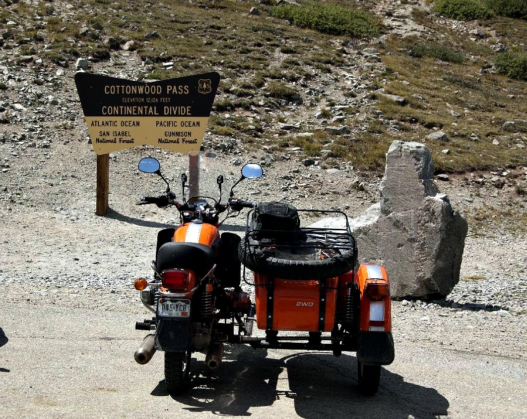
Valencia and I continued south now on US24 from Twin Lakes and soon were were within the borders of the town of Buena Vista. I found my way onto CO306 and headed west of of town towards the next pass on the list, Cottonwood Pass.
It took about 30 minutes with some really steep, twisty hairpin turns finally getting us to the summit of Cottonwood Pass. This road is apparently pretty easy and a favorite of RV Campers and trucks pulling trailers laden with ATVs to get west to the Gunnison Area.

Part of the view from the summit of Cottonwood Pass,
looking westward

The eastern portion of Cottonwood Pass Road is very nicely paved.
The Western Half is nicely packed dirt.
After a snack, I headed down the western part of the road for a bit, I wanted to get a bit closer to the peaks I'd seen from the summit:


Turning back towards Buena Vista, Valencia and I transited this town and continued south for a few miles to the junction with US285. Turning east, it was time to tank up one more time, a quick energy drink and then almost three hours more of riding to get home.
Valencia went over 10,000 Kilometers somewhere near Buena Vista and I must say, the predicted "loosening up" of the engine has happened! She pulls stronger on the uphill portions and she now holds an indicated 65 MPH without too much trouble, the tachometer indicating around 4300-4500 RPM.
Heck, I didn't have to shift into third gear to get up most of the hills between Buena Vista and home! In some hills, fourth gear was enough to keep Valencia going above 50 MPH and there were times I even managed to accelerate while going uphill! That is a novel thing for this Ural rider!
Heck, I even managed to pass a couple of slow trucks while on an uphill!
Tomorrow, it'll be time for Valencia's 10,000 KM service, I also want to "inspect" the bearings on the pusher wheel, perhaps add a bit of grease to these sealed bearings. I had been checking the temperature of the hub during stops, and it was just warm to the touch, which is good. There's also a vibration seemingly from the tires, when at over 55 mph or so...hmmm.
Quite the weekend for Valencia and I.
9 comments:
That was quite the weekend! Wonderful images. You do such a good job getting nice backdrops for Valencia. I never get tired of the scenery in your area. Nice ride report!
Thanks for the kind words!
Great landscape views from a great ride! Do you mind if I showcase one of your photos on my Facebook motorcycle page (dffl.old.skool)? I will link it back to your blog.
Respectfully, Shade
Debb, thanks and sure, link away....
Dom,
Quite the weekend indeed. All that haze puts a longing for the Blue Ridge in my heart, but I've got to say, wherever you park that mandarin machine it looks good. Orange really pops in the photos, of course, Colorado helps a whole hell of a lot, but I think your photography has improved since I started visiting.
Brady
Behind Bars - Motorcycles and Life
I left a comment last week but it must have gotten lost. Or you deleted it. I think it was something insulting about orange URALs. I can't remember.
But I will say again the landscape in which you ride is amazing. And it seems as if the URAL is living up to and exceeding your expectations.
Is that the case?
Not that I want one or anything...
Steve Williams
Scooter in the Sticks
So Brady, are you saying My pics sucked before?
Sniff.....
Dom
Steve
My Valencia is doing great by me....you need to overcome this denial issue and get one as well! Then I will no longer have the slight advantage that the rig's color gives me....to enable me to come close to your picture quality.
Post a Comment